IMAGES TAKEN NEAR TO
Clapham High Street, LONDON, SW4 7UL
Introduction
This page details the photographs taken nearby to Clapham High Street, SW4 7UL by members of the Geograph project.
The Geograph project started in 2005 with the aim of publishing, organising and preserving representative images for every square kilometre of Great Britain, Ireland and the Isle of Man.

There are currently over 7.5m images from over14,400 individuals and you can help contribute to the project by visiting https://www.geograph.org.uk
Image Map
Images are licensed for reuse under creativecommons.org/licenses/by-sa/2.0
Notes
- Clicking on the map will re-center to the selected point.
- The higher the marker number, the further away the image location is from the centre of the postcode.
Image Listing (290 Images Found)
Images are licensed for reuse under creativecommons.org/licenses/by-sa/2.0
Image
Details
Distance
2
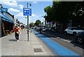
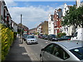
CS7 cycleway beside Clapham High Street
A3 towards Central London.
Image: © JThomas
Taken: 29 Jul 2022
0.01 miles
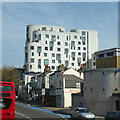
4
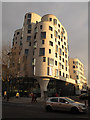
Mary Seacole Centre, Clapham
The Mary Seacole Centre is on the corner of Clapham High Street and St Luke's Avenue, and opened in 2012. The ground floor consists of a library (at this corner), leisure centre and health centre. The whole site is called Clapham One, including the flats above Image
Image: © Stephen Craven
Taken: 13 Jan 2013
0.03 miles
5
Edgeley Road SW4
A side street in Clapham, off Clapham High Street.
Image: © Danny P Robinson
Taken: 21 Jun 2006
0.03 miles
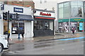
6
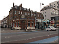
Streathers Solicitors
The firm occupies this building on the corner of Clapham High Street and Tremadoc Road.
Image: © Stephen Craven
Taken: 13 Jan 2013
0.03 miles
7
Mary Seacole Centre, Clapham
Apparently flats at the top, a range of public services and the like lower down.
Image: © Robin Webster
Taken: 19 Apr 2019
0.04 miles
8
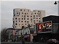
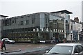
Flats above the Mary Seacole Centre
A recent medium-rise development, above the Mary Seacole Centre on the corner of Clapham High Street and St Luke's Avenue, opened in 2012. The whole site is called Clapham One, "a public private partnership scheme between the London Borough of Lambeth, Cathedral Group Plc and United House Limited ... a new 20,000 sq ft health centre, library, leisure centre and 199 new homes" (from the architects' website).
The building in the right foreground looks uninteresting and abandoned; in fact (according to another contributor to this site) it was the entrance to a WW2 deep level air raid shelter Image
Image: © Stephen Craven
Taken: 13 Jan 2013
0.04 miles
10
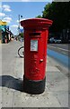
Edward VII postbox on Clapham High Street
Postbox No. SW4 29.
Image: © JThomas
Taken: 29 Jul 2022
0.04 miles