IMAGES TAKEN NEAR TO
Tintern Street, LONDON, SW4 7PY
Introduction
This page details the photographs taken nearby to Tintern Street, SW4 7PY by members of the Geograph project.
The Geograph project started in 2005 with the aim of publishing, organising and preserving representative images for every square kilometre of Great Britain, Ireland and the Isle of Man.

There are currently over 7.5m images from over14,400 individuals and you can help contribute to the project by visiting https://www.geograph.org.uk
Image Map
Images are licensed for reuse under creativecommons.org/licenses/by-sa/2.0
Notes
- Clicking on the map will re-center to the selected point.
- The higher the marker number, the further away the image location is from the centre of the postcode.
Image Listing (61 Images Found)
Images are licensed for reuse under creativecommons.org/licenses/by-sa/2.0
Image
Details
Distance
1
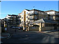
Rubens Place, SW4
The flats in this gated community are between Ferndale Road and the railway line heading out of Victoria.
Image: © Danny P Robinson
Taken: 21 Nov 2007
0.05 miles
2
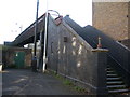
Footbridge Over Railway
Taken from Hubert Grove. The footbridge goes to Dolman Street which will then very soon lead to Ferndale Road. This photo was taken from the bridge, looking towards Brixton, (left from here) Image
Image: © Danny P Robinson
Taken: 21 Nov 2007
0.08 miles
3
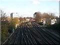
Railway Lines in Brixton
Taken from the footbridge Image over the line between Hubert Grove and Dolman Street. This section of track is between Clapham High Street and Brixton Stations, looking towards Brixton.
Image: © Danny P Robinson
Taken: 21 Nov 2007
0.08 miles
5
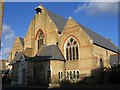
Adventist Church, Santley Street
St Paul's was erected by the Rev G Blake Concannon, at a cost of £16,000, and Consecrated by the Bishop of Rochester on 29 July 1881. Originally seating 1500 people (including galleries which were later removed), it is in decorated Gothic style. A planned tower at the west end was never built. It was declared redundant by the Anglican church in 1980, and exchanged for the smaller Seventh Day Adventist church Image on Ferndale Road (built 1958). It is still used by the Adventists.
Image: © Stephen Craven
Taken: 21 Nov 2006
0.08 miles
6
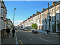
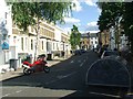
Sandmere Road, SW4
Near the corner of Tintern Street. Parking is for residents only -- if it was unrestricted the road would be jammed with parked commuters cars.
Image: © Danny P Robinson
Taken: 21 Nov 2007
0.10 miles
7
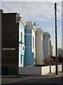
Houses on Ferndale Road, SW9
A staggered sequence of painted brick houses at the west end of a terrace between Dolman Street and Glendall Street.
Image: © Derek Harper
Taken: 11 Mar 2011
0.11 miles
8
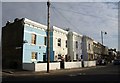
Houses on Ferndale Road, SW9
Another view of the staggered terrace shown in Image, each house with a smart cornice.
Image: © Derek Harper
Taken: 11 Mar 2011
0.11 miles
9
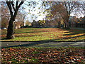
City of London Almshouses and Green, Ferndale Road, SW9
The Almshouses were built as social housing in the latter half of the 19th century. Most of the current residents are nominated by Lambeth Council now. Read more via these 2 links http://www.british-history.ac.uk/report.aspx?compid=49766 http://www.brixtonsociety.org.uk/trailtwo.htm
Image: © Danny P Robinson
Taken: 21 Nov 2007
0.11 miles
10
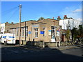
St Paul's Church, Ferndale Road, SW9
At the corner of Glendall Street. This church was built in 1958 and was once the Brixton Seventh-Day Adventist Church. During the 1970s the congregation was fast outgrowing the building. The Church of England occupied a much larger church at Santley Street Image but was beginning to find it much too large for their needs. So an arrangement was made for the two churches to swap premises -- this happened in 1980.
Image: © Danny P Robinson
Taken: 21 Nov 2007
0.11 miles