IMAGES TAKEN NEAR TO
Jeffreys Road, LONDON, SW4 6QS
Introduction
This page details the photographs taken nearby to Jeffreys Road, SW4 6QS by members of the Geograph project.
The Geograph project started in 2005 with the aim of publishing, organising and preserving representative images for every square kilometre of Great Britain, Ireland and the Isle of Man.

There are currently over 7.5m images from over14,400 individuals and you can help contribute to the project by visiting https://www.geograph.org.uk
Image Map (Loading...)


Getting Data...Please wait
Leaflet Map data © OpenStreetMap
Images are licensed for reuse under creativecommons.org/licenses/by-sa/2.0
Notes
- Clicking on the map will re-center to the selected point.
- The higher the marker number, the further away the image location is from the centre of the postcode.
Image Listing (147 Images Found)
Images are licensed for reuse under creativecommons.org/licenses/by-sa/2.0
Image
Details
Distance
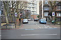
1
Pair of pre-Worboys signs, Levehurst Way, Stockwell
Until recently at least three Lambeth Council estates still had their pre-Worboys signs in place, luckily I discovered them all before they started removing them around 2010.
Image: © David Howard
Taken: 6 Jul 2009
0.02 miles
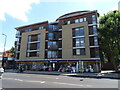
3
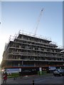
Construction site on Clapham Road
Development of an apartment block at 330 Clapham Road
Image: © David Smith
Taken: 17 Nov 2016
0.06 miles
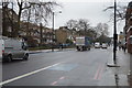
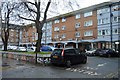
6
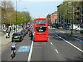
A3, Clapham Road, Stockwell
Also cycle route CS7, and it is quite well used here.
Image: © Robin Webster
Taken: 19 Apr 2019
0.06 miles
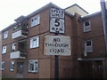
7
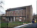
Stockwell Methodist Church
On Jeffrey's Road.
Image: © David Anstiss
Taken: 30 Dec 2012
0.07 miles