IMAGES TAKEN NEAR TO
Herbert Mews, LONDON, SW2 2YG
Introduction
This page details the photographs taken nearby to Herbert Mews, SW2 2YG by members of the Geograph project.
The Geograph project started in 2005 with the aim of publishing, organising and preserving representative images for every square kilometre of Great Britain, Ireland and the Isle of Man.

There are currently over 7.5m images from over14,400 individuals and you can help contribute to the project by visiting https://www.geograph.org.uk
Image Map (Loading...)


Getting Data...Please wait
Leaflet Map data © OpenStreetMap
Images are licensed for reuse under creativecommons.org/licenses/by-sa/2.0
Notes
- Clicking on the map will re-center to the selected point.
- The higher the marker number, the further away the image location is from the centre of the postcode.
Image Listing (38 Images Found)
Images are licensed for reuse under creativecommons.org/licenses/by-sa/2.0
Image
Details
Distance
1
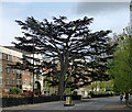
Cedar, Tulse Hill
A sublime Cedar of Lebanon.
Image: © Stephen Richards
Taken: 5 May 2012
0.03 miles
2
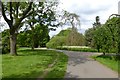
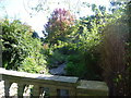
Path near the ponds
Looking towards some of the ponds in Brockwell Park.
Image: © DS Pugh
Taken: 22 May 2016
0.07 miles
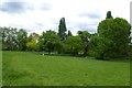
3
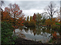
Brockwell Park (15)
Originally the grounds of Brockwell Hall, landscaped by J.B. Papworth, acquired from the Brockwell Estate by the London County Council in 1891, and later extended under the guiding hand of their Superintendent of Parks, Colonel J.J. Sexby, who added ponds, lakes, bandstand and walled garden. The park covers some 120 acres, including the popular lido. The hall now serves as the park's cafe (Image]).
The tree on the left by a pond is a species of maple; on the right is an oak.
Image: © Stephen Richards
Taken: 17 Nov 2012
0.08 miles
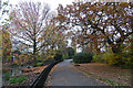
4
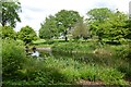
Park near Brockwell Park Row
Looking across a corner of the park near Brockwell Park Row.
Image: © DS Pugh
Taken: 22 May 2016
0.08 miles
5
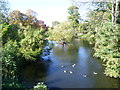
Pond in Brockwell Park
The three ponds along the western side of Brockwell Park follow the line of the lost River Effra. The line of the Effra can be seen below the lowest of the ponds - see http://www.geograph.org.uk/photo/2636375. Presumably these ponds were formed by damming the river. The upper reaches of the River Effra remained clean and open well into the 19th century. In 1860 it was still "an open, clear, and sparkling brook" which ran "over a gravelly bottom through the fields and supplied fresh water to the neighbourhood". By the end of the 19th century it had all been bricked over. Apart from this stream and the ponds in Brockwell Park, only valleys such as the one which Leigham Vale follows - see http://www.geograph.org.uk/photo/2052759 , air vents as in Brockwell Park near Rosendale Road, and names such as Brixton Water Lane indicate where the Effra flows.
Image: © Marathon
Taken: 28 Sep 2011
0.09 miles
6
Pond in Brockwell Park
The three ponds along the western side of Brockwell Park follow the line of the lost River Effra. The line of the Effra can be seen below the lowest of the ponds - see http://www.geograph.org.uk/photo/2636375. Presumably these ponds were formed by damming the river. The upper reaches of the River Effra remained clean and open well into the 19th century. In 1860 it was still "an open, clear, and sparkling brook" which ran "over a gravelly bottom through the fields and supplied fresh water to the neighbourhood". By the end of the 19th century it had all been bricked over. Apart from this stream and the ponds in Brockwell Park, only valleys such as the one which Leigham Vale follows - see http://www.geograph.org.uk/photo/2052759 , air vents as in Brockwell Park near Rosendale Road, and names such as Brixton Water Lane indicate where the Effra flows.
Image: © Marathon
Taken: 28 Sep 2011
0.09 miles
7
Lake, Brockwell Park
Originally the grounds of Brockwell Hall, landscaped by J.B. Papworth, acquired from the Brockwell Estate by the London County Council in 1891, and later extended under the guiding hand of their Superintendent of Parks, Colonel J.J. Sexby, who added ponds, lakes, bandstand and walled garden. The park covers some 120 acres, including the popular lido. The hall now serves as the park's cafe (Image]).
A gorgeous autumn display courtesy of maples, poplars, a Swamp cypress and many others.
Image: © Stephen Richards
Taken: 17 Nov 2012
0.09 miles
8
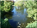
Pond in Brockwell Park
Looking over a pool on the western edge of the park.
Image: © DS Pugh
Taken: 22 May 2016
0.09 miles
9
Tributary of the River Effra
This small stream below the three ponds in Brockwell Park is the only place where the lost River Effra can be seen above ground, although on this day it was dry. The upper reaches of the River Effra remained clean and open well into the 19th century. In 1860 it was still "an open, clear, and sparkling brook" which ran "over a gravelly bottom through the fields and supplied fresh water to the neighbourhood". By the end of the 19th century it had all been bricked over. Apart from this stream and the ponds in Brockwell Park, only valleys such as the one which Leigham Vale follows - see http://www.geograph.org.uk/photo/2052759 , air vents as in Brockwell Park near Rosendale Road, and names such as Brixton Water Lane indicate where the Effra flows.
Image: © Marathon
Taken: 28 Sep 2011
0.09 miles
10
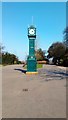
Tritton Clock in Brockwell Park
The clock was given to the public by the MP for Norwood, Charles Ernest Tritton in 1897 to mark Queen Victoria’s Diamond Jubilee.
Image: © PAUL FARMER
Taken: 17 Mar 2016
0.10 miles