IMAGES TAKEN NEAR TO
Brixton Hill, LONDON, SW2 1NP
Introduction
This page details the photographs taken nearby to Brixton Hill, SW2 1NP by members of the Geograph project.
The Geograph project started in 2005 with the aim of publishing, organising and preserving representative images for every square kilometre of Great Britain, Ireland and the Isle of Man.

There are currently over 7.5m images from over14,400 individuals and you can help contribute to the project by visiting https://www.geograph.org.uk
Image Map
Images are licensed for reuse under creativecommons.org/licenses/by-sa/2.0
Notes
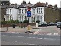
- Clicking on the map will re-center to the selected point.
- The higher the marker number, the further away the image location is from the centre of the postcode.
Image Listing (103 Images Found)
Images are licensed for reuse under creativecommons.org/licenses/by-sa/2.0
Image
Details
Distance
2
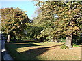
Rush Common
Thin open-space ground beside the A23 Brixton Hill.
Image: © David Anstiss
Taken: 2 Oct 2011
0.02 miles
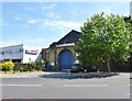
3
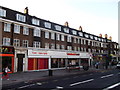
Sainsbury's Local, Streatham Hill
Mini supermarket on the A23 Brixton Hill.
Image: © David Anstiss
Taken: 2 Oct 2011
0.04 miles
4
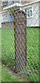
Old Boundary Marker on Rush Common, Brixton Hill
Parish Boundary Marker in parish of Brixton (Lambeth District), Rush Common SW2, South end of common against wire fence of Roupell Park Estate.
Inscription reads:-
LP
1862
Surveyed
Milestone Society National ID: SY_LAMB03pb
Image: © Milestone Society
Taken: Unknown
0.04 miles
5
Brixton Hill, former tram depot
On Brixton Hill; the building has a sign calling it "L.C.C. Tramways", and is dated 1923. It is now used as a part-time bus garage.
Image: © Mike Faherty
Taken: 18 Aug 2012
0.06 miles
6
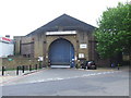
Former tram depot, Brixton Hill
This former tram depot was reopened to house buses in 2003, to enable the bus fleet to increase as services were expanded. On Sundays and Bank Holidays, however, the shed is closed as there are fewer buses operating. The larger depot a short distance along the road is able to provide enough buses to run the Sunday/Bank Holiday service, while this depot is used to house buses which are not required on that day.
Image: © Malc McDonald
Taken: 30 May 2011
0.08 miles
7
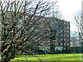
Rush Common
The common is the strip of parkland in the foreground which lies between Brixton Hill Rd and the blocks of flats which are in Redlands Way.
Image: © Nigel Mykura
Taken: 5 Mar 2013
0.08 miles
8
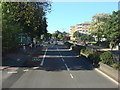
A23, Streatham Hill
Approaching the junction with the A205, South Circular Road
Image: © Oxyman
Taken: 29 May 2009
0.09 miles
9
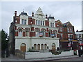
The Telegraph, Brixton Hill
The Telegraph, a disused pub on Brixton Hill in South London.
Image: © Malc McDonald
Taken: 30 May 2011
0.10 miles
10
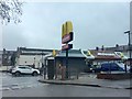
Streatham McDonald's
McDonald's in Streatham Place.
Image: © Alan Hughes
Taken: 20 Jan 2018
0.10 miles