IMAGES TAKEN NEAR TO
Orchard Close, LONDON, SW20 9HU
Introduction
This page details the photographs taken nearby to Orchard Close, SW20 9HU by members of the Geograph project.
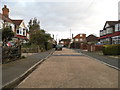
The Geograph project started in 2005 with the aim of publishing, organising and preserving representative images for every square kilometre of Great Britain, Ireland and the Isle of Man.

There are currently over 7.5m images from over14,400 individuals and you can help contribute to the project by visiting https://www.geograph.org.uk
Image Map
Images are licensed for reuse under creativecommons.org/licenses/by-sa/2.0
Notes
- Clicking on the map will re-center to the selected point.
- The higher the marker number, the further away the image location is from the centre of the postcode.
Image Listing (18 Images Found)
Images are licensed for reuse under creativecommons.org/licenses/by-sa/2.0
Image
Details
Distance
1
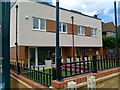
2 new houses, Grand Drive, Raynes Park
Image: © Alex McGregor
Taken: 22 Jun 2011
0.03 miles
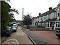
2
Bushey Mead: Greenway
From Grand Drive, (B279) looking west
Image: © Dr Neil Clifton
Taken: 23 Jul 2013
0.11 miles
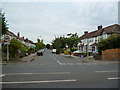
3
Bushey Mead: Meadway
Looking east from its junction with Grand Drive (B279)
Image: © Dr Neil Clifton
Taken: 23 Jul 2013
0.13 miles
4
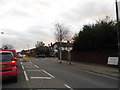
Grand Drive at the junction of Crossway
Image: © David Howard
Taken: 4 Feb 2013
0.15 miles
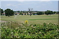
5
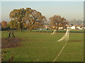
Bushey Mead
Goalposts and a rutted track on the west side of the King George V playing fields. A row of oak trees marks an old field boundary.
Image: © Derek Harper
Taken: 16 Nov 2010
0.16 miles
6
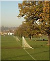
Goalposts, Bushey Mead
These football posts correspond to those shown in Image, which are at the western end of the respective pitches. Another line of oaks here, at right angles to those in that photo.
Image: © Derek Harper
Taken: 16 Nov 2010
0.18 miles
7
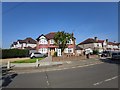
Corner Semi-detached house
End of Fairway.
Image: © James Emmans
Taken: 9 May 2020
0.19 miles
8
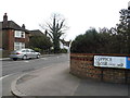
Coppice Close at the junction of Grand Drive
Image: © David Howard
Taken: 4 Feb 2013
0.20 miles
10
Prince George's Playing Field
On the skyline is Wimbledon Hill. Whilst I am aware of numerous King George's Playing Fields created around the country, I wasn't aware of a Prince George engaging in similar activity.
Image: © Bill Boaden
Taken: 1 Aug 2011
0.21 miles