IMAGES TAKEN NEAR TO
Coppice Close, LONDON, SW20 9AS
Introduction
This page details the photographs taken nearby to Coppice Close, SW20 9AS by members of the Geograph project.
The Geograph project started in 2005 with the aim of publishing, organising and preserving representative images for every square kilometre of Great Britain, Ireland and the Isle of Man.

There are currently over 7.5m images from over14,400 individuals and you can help contribute to the project by visiting https://www.geograph.org.uk
Image Map
Images are licensed for reuse under creativecommons.org/licenses/by-sa/2.0
Notes
- Clicking on the map will re-center to the selected point.
- The higher the marker number, the further away the image location is from the centre of the postcode.
Image Listing (48 Images Found)
Images are licensed for reuse under creativecommons.org/licenses/by-sa/2.0
Image
Details
Distance
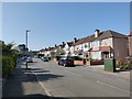
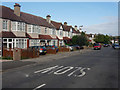
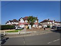
2
Coppice Close at the junction of Grand Drive
Image: © David Howard
Taken: 4 Feb 2013
0.04 miles
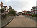
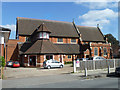
4
Corner Semi-detached house
End of Fairway.
Image: © James Emmans
Taken: 9 May 2020
0.06 miles
5
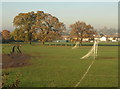
Bushey Mead
Goalposts and a rutted track on the west side of the King George V playing fields. A row of oak trees marks an old field boundary.
Image: © Derek Harper
Taken: 16 Nov 2010
0.07 miles
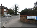
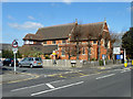
6
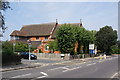
Church of St Saviour, Raynes Park
Situated on Grand Drive, the B279.
Image: © Bill Boaden
Taken: 1 Aug 2011
0.08 miles
7
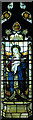
St Saviour, Grand Drive, Raynes Park, Merton - Window
Madonna & Child
Image: © John Salmon
Taken: 8 Jun 2005
0.09 miles
8
Raynes Park parish church
St. Saviour's.
Image: © Robin Webster
Taken: 1 Apr 2012
0.09 miles
9
Raynes Park parish church
St. Saviour's.
Image: © Robin Webster
Taken: 1 Apr 2012
0.09 miles