IMAGES TAKEN NEAR TO
Aboyne Drive, LONDON, SW20 0AL
Introduction
This page details the photographs taken nearby to Aboyne Drive, SW20 0AL by members of the Geograph project.
The Geograph project started in 2005 with the aim of publishing, organising and preserving representative images for every square kilometre of Great Britain, Ireland and the Isle of Man.

There are currently over 7.5m images from over14,400 individuals and you can help contribute to the project by visiting https://www.geograph.org.uk
Image Map
Images are licensed for reuse under creativecommons.org/licenses/by-sa/2.0
Notes
- Clicking on the map will re-center to the selected point.
- The higher the marker number, the further away the image location is from the centre of the postcode.
Image Listing (9 Images Found)
Images are licensed for reuse under creativecommons.org/licenses/by-sa/2.0
Image
Details
Distance
1
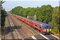
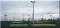
Railway near New Malden
Local train to the east of New Malden.
Image: © Wayland Smith
Taken: 4 Aug 2018
0.14 miles
5
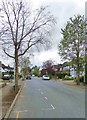
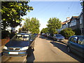
Coombe Gardens, SW20
A between-the-wars residential street off Coombe Lane - and pretty typical of the area. It is in fact a cul-de-sac, so that traffic is very light.
Image: © Stefan Czapski
Taken: 15 Apr 2018
0.20 miles
6
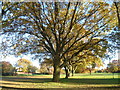
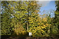
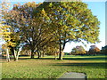
Malden Golf Course in autumn
Malden Golf Course is situated on what was once Norbiton Common, and later became part of Hoppingwood Farm. The name Hoppinge is very old and may be the ancient name for flat land either side of a river (in this case Beverley Brook), perhaps referring to land where hops grew wild. The farm disappeared from maps after 1911. The golf course was opened in 1926. It is bisected by an east-west footpath which connects the A3 Beverley Way with Cambridge Avenue in New Malden. This gives views of the golf course, which is otherwise private. This is the southern part of the golf course, close to the footpath. The Beverley Brook runs through this part of the golf course in the distance.
Image: © Marathon
Taken: 14 Nov 2012
0.21 miles
7
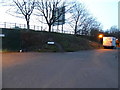
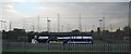
Bodnant Gardens by the A3, Raynes Park
Image: © David Howard
Taken: 22 Feb 2014
0.23 miles
8
Malden Golf Course in autumn
Malden Golf Course is situated on what was once Norbiton Common, and later became part of Hoppingwood Farm. The name Hoppinge is very old and may be the ancient name for flat land either side of a river (in this case Beverley Brook), perhaps referring to land where hops grew wild. The farm disappeared from maps after 1911. The golf course was opened in 1926. It is bisected by an east-west footpath which connects the A3 Beverley Way with Cambridge Avenue in New Malden. This gives views of the golf course, which is otherwise private. This is the southern part of the golf course, close to the footpath. The Beverley Brook runs through this part of the golf course in the distance.
Image: © Marathon
Taken: 14 Nov 2012
0.23 miles