IMAGES TAKEN NEAR TO
Huntley Way, LONDON, SW20 0AH
Introduction
This page details the photographs taken nearby to Huntley Way, SW20 0AH by members of the Geograph project.
The Geograph project started in 2005 with the aim of publishing, organising and preserving representative images for every square kilometre of Great Britain, Ireland and the Isle of Man.

There are currently over 7.5m images from over14,400 individuals and you can help contribute to the project by visiting https://www.geograph.org.uk
Image Map (Loading...)


Getting Data...Please wait
Leaflet Map data © OpenStreetMap
Images are licensed for reuse under creativecommons.org/licenses/by-sa/2.0
Notes
- Clicking on the map will re-center to the selected point.
- The higher the marker number, the further away the image location is from the centre of the postcode.
Image Listing (20 Images Found)
Images are licensed for reuse under creativecommons.org/licenses/by-sa/2.0
Image
Details
Distance
1
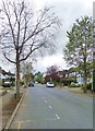
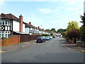
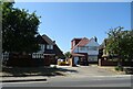
Coombe Gardens, SW20
A between-the-wars residential street off Coombe Lane - and pretty typical of the area. It is in fact a cul-de-sac, so that traffic is very light.
Image: © Stefan Czapski
Taken: 15 Apr 2018
0.12 miles
2
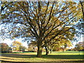
Malden Golf Course in autumn
Malden Golf Course is situated on what was once Norbiton Common, and later became part of Hoppingwood Farm. The name Hoppinge is very old and may be the ancient name for flat land either side of a river (in this case Beverley Brook), perhaps referring to land where hops grew wild. The farm disappeared from maps after 1911. The golf course was opened in 1926. It is bisected by an east-west footpath which connects the A3 Beverley Way with Cambridge Avenue in New Malden. This gives views of the golf course, which is otherwise private. This is the southern part of the golf course, close to the footpath. The Beverley Brook runs through this part of the golf course in the distance.
Image: © Marathon
Taken: 14 Nov 2012
0.14 miles
3
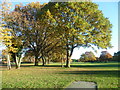
Malden Golf Course in autumn
Malden Golf Course is situated on what was once Norbiton Common, and later became part of Hoppingwood Farm. The name Hoppinge is very old and may be the ancient name for flat land either side of a river (in this case Beverley Brook), perhaps referring to land where hops grew wild. The farm disappeared from maps after 1911. The golf course was opened in 1926. It is bisected by an east-west footpath which connects the A3 Beverley Way with Cambridge Avenue in New Malden. This gives views of the golf course, which is otherwise private. This is the southern part of the golf course, close to the footpath. The Beverley Brook runs through this part of the golf course in the distance.
Image: © Marathon
Taken: 14 Nov 2012
0.15 miles
4
Beverley Way, near Raynes Park
Beverley Way is a road which runs alongside the A3 Kingston-by-pass.
To the right of the image is a subway which enables pedestrians and cyclists to get across the A3.
Image: © Malc McDonald
Taken: 1 Jul 2018
0.15 miles
5
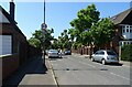
Ely Close, near New Malden
Ely Close is a residential cul-de-sac in the outer suburbs of south west London.
Image: © Malc McDonald
Taken: 1 Jul 2018
0.17 miles
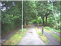
6
Path across Malden Golf Course
Malden Golf Course is situated on what was once Norbiton Common, and later became part of Hoppingwood Farm. The name Hoppinge is very old and may be the ancient name for flat land either side of a river (in this case Beverley Brook), perhaps referring to land where hops grew wild. The farm disappeared from maps after 1911. The golf course was opened in 1926. It is bisected by an east-west footpath which connects the A3 Beverley Way with Cambridge Avenue in New Malden. This gives views of the golf course, which is otherwise private. This is the approach from Beverley Way with the golf course to the right and left.
Image: © Marathon
Taken: 14 Nov 2012
0.18 miles
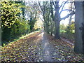
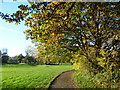
7
Footpath across Malden Golf Course.
A leafy stretch of the Beverley Brook Walk. Also one of London's many cycle ways.
Image: © Noel Foster
Taken: 1 Aug 2005
0.19 miles
10
Malden Golf Course in autumn
Malden Golf Course is situated on what was once Norbiton Common, and later became part of Hoppingwood Farm. The name Hoppinge is very old and may be the ancient name for flat land either side of a river (in this case Beverley Brook), perhaps referring to land where hops grew wild. The farm disappeared from maps after 1911. The golf course was opened in 1926. It is bisected by an east-west footpath which connects the A3 Beverley Way with Cambridge Avenue in New Malden. This gives views of the golf course, which is otherwise private. The Beverley Brook runs through the southern part of the golf course. This is the northern part of the golf course, close to the footpath.
Image: © Marathon
Taken: 14 Nov 2012
0.21 miles