IMAGES TAKEN NEAR TO
Durnsford Road, LONDON, SW19 8HJ
Introduction
This page details the photographs taken nearby to Durnsford Road, SW19 8HJ by members of the Geograph project.
The Geograph project started in 2005 with the aim of publishing, organising and preserving representative images for every square kilometre of Great Britain, Ireland and the Isle of Man.

There are currently over 7.5m images from over14,400 individuals and you can help contribute to the project by visiting https://www.geograph.org.uk
Image Map (Loading...)


Getting Data...Please wait
Leaflet Map data © OpenStreetMap
Images are licensed for reuse under creativecommons.org/licenses/by-sa/2.0
Notes
- Clicking on the map will re-center to the selected point.
- The higher the marker number, the further away the image location is from the centre of the postcode.
Image Listing (35 Images Found)
Images are licensed for reuse under creativecommons.org/licenses/by-sa/2.0
Image
Details
Distance
1
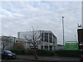
Wimbledon Homebase
This large DIY superstore is on Durnsford Road, accessed by car from Weir Road.
Image: © David Anstiss
Taken: 13 Jan 2013
0.10 miles
2
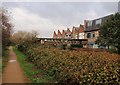
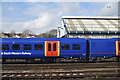
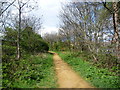
Wandle Trail, Wimbledon
Across the river, crossed by an unprepossessing bridge, is part of the Wimbledon Stadium Business Centre. Among the assorted occupants of the premises visible are, I think, a printer, dry cleaner and clock manufacturer.
Image: © Derek Harper
Taken: 30 Nov 2009
0.11 miles
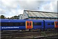
4
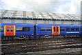
Maintenance Platform, Wimbledon
As seen from Durnsford Road bridge. This small platform (I assume) is used by maintenance workers boarding trains near the Wimbledon traincare depot. The main line (on the right) heads towards Wimbledon from Earlsfield.
Image: © David Anstiss
Taken: 13 Jan 2013
0.13 miles
7
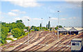
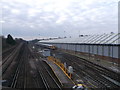
Wimbledon Train-care Depot
View NW from an Up Local line train on the Durnsford Road fly-over: ex-LSWR main line to Waterloo, north of the junction with the Joint line (with the ex-Metropolitan District line to Putney Bridge, thence Earl's Court to Central London) - see train receding away on the left. The flyover on the main line was built in the 1930s, while the Train-care Depot is an extended version of an earlier depot, built here after demolition of the Durnsford Road power station that used to provide power for the electrified ex-LSWR lines from Waterloo. (Cf. Image]). [What is the small shed on the right?]
Image: © Ben Brooksbank
Taken: 24 May 2011
0.13 miles
8
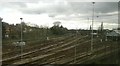
Junction and depot, Wimbledon Park
Taken from the flyover that carries Up Slow trains over the fast tracks: beyond this point towards Waterloo a pair of slow tracks lie to the east of a pair of fast ones, whilst further out slow tracks are on either side of a central pair of fast ones.
Image: © Christopher Hilton
Taken: 10 Feb 2016
0.16 miles
9
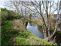
The Wandle Trail north of Plough Lane
The section of the River Wandle and the Wandle Trail between Plough Lane and Earlsfield has commerce on the right bank, followed by allotments, and a housing estate, on the site of the old Wimbledon F. C. ground, on the left bank followed by more commerce. Here commercial premises are on both sides. The river is to the right.
Image: © Marathon
Taken: 11 Apr 2012
0.17 miles
10
River Wandle near Wimbledon Stadium
The section of the River Wandle and the Wandle Trail between Plough Lane and Earlsfield has commerce on the right bank, followed by allotments, and a housing estate, on the site of the old Wimbledon F. C. ground, on the left bank followed by more commerce. Here commercial premises are on both sides. The Wandle Trail can just be glimpsed on the left.
Image: © Marathon
Taken: 11 Apr 2012
0.17 miles