IMAGES TAKEN NEAR TO
Home Park Road, LONDON, SW19 7HT
Introduction
This page details the photographs taken nearby to Home Park Road, SW19 7HT by members of the Geograph project.
The Geograph project started in 2005 with the aim of publishing, organising and preserving representative images for every square kilometre of Great Britain, Ireland and the Isle of Man.

There are currently over 7.5m images from over14,400 individuals and you can help contribute to the project by visiting https://www.geograph.org.uk
Image Map
Images are licensed for reuse under creativecommons.org/licenses/by-sa/2.0
Notes
- Clicking on the map will re-center to the selected point.
- The higher the marker number, the further away the image location is from the centre of the postcode.
Image Listing (39 Images Found)
Images are licensed for reuse under creativecommons.org/licenses/by-sa/2.0
Image
Details
Distance
1
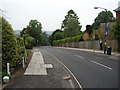
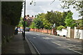
Down Home Park Road
View north-east, downhill in the direction of the golf course.
Image: © Ian Paterson
Taken: 13 May 2009
0.03 miles
2
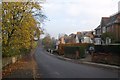
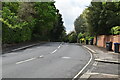
Home Park Road, Wimbledon
One side of the road is lined with detached houses, which have a fine view over Wimbledon Park to the left.
Image: © Derek Harper
Taken: 16 Nov 2010
0.06 miles
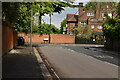
4
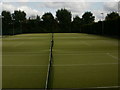
Green, Wimbledon Park Golf Club
A view that owes a good deal to Capability Brown, who designed the park for Lord Spencer in the 1760s. The southwest corner of his lake, visible above the yellow flag, is in Image The golf club dates from 1898, although the park had been used for various recreational activities after the fourth Earl Spencer sold it in 1864 http://www.wphg.demon.co.uk/golf_club.htm http://www.wpgc.co.uk/main/golf_course.php?content=heritage . View from Home Park Road.
Image: © Derek Harper
Taken: 16 Nov 2010
0.10 miles

10

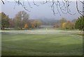
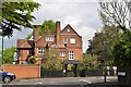
Artesian Well
The plaque on the side of the property reads:
'Built to provide water for Earl Spencer's house, nearby in 1763. In 1798 the well was increased in depth to over 500ft, but it soon silted up. The building was converted to a private house in 1976.'
The building is one of the waypoints in the local Heritage Trail.
Image: © Ian Paterson
Taken: 13 May 2009
0.16 miles