IMAGES TAKEN NEAR TO
Edge Hill, LONDON, SW19 4LL
Introduction
This page details the photographs taken nearby to Edge Hill, SW19 4LL by members of the Geograph project.
The Geograph project started in 2005 with the aim of publishing, organising and preserving representative images for every square kilometre of Great Britain, Ireland and the Isle of Man.

There are currently over 7.5m images from over14,400 individuals and you can help contribute to the project by visiting https://www.geograph.org.uk
Image Map (Loading...)


Getting Data...Please wait
Leaflet Map data © OpenStreetMap
Images are licensed for reuse under creativecommons.org/licenses/by-sa/2.0
Notes
- Clicking on the map will re-center to the selected point.
- The higher the marker number, the further away the image location is from the centre of the postcode.
Image Listing (22 Images Found)
Images are licensed for reuse under creativecommons.org/licenses/by-sa/2.0
Image
Details
Distance
1
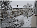
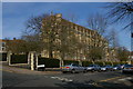
Edge Hill Court
View of Edge Hill Court, Edge Hill, Wimbledon. Snowy. Built in 1935.
Image: © Matt Baines
Taken: 2 Feb 2009
0.01 miles
2
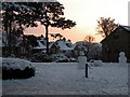
Edge Hill - snowy
View of Edge Hill from the grounds of Edge Hill Court, Wimbledon. Viewed looking eastwards on a snowy morning, looking at the houses going down the slope.
Image: © Matt Baines
Taken: 3 Feb 2009
0.05 miles
3
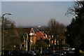
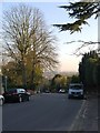
Edge Hill, Wimbledon
Dropping steeply off Wimbledon Common, this road offers large views across South London.
Image: © Christopher Hilton
Taken: 25 Mar 2012
0.07 miles
4
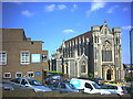
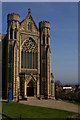
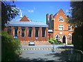
Sacred Heart Church, Edge Hill, Wimbledon.
Roman Catholic Church.
Image: © Noel Foster
Taken: 18 Jun 2005
0.07 miles
5
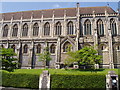
Church of the Sacred Heart, Edge Hill, Wimbledon
Image: © Christopher Hilton
Taken: 25 Mar 2012
0.10 miles
6
Church of the Sacred Heart, Edge Hill, Wimbledon
Image: © Christopher Hilton
Taken: 25 Mar 2012
0.10 miles
7
The Downs, Wimbledon
The road gradient here is one of the steepest for miles around - closely matched by Edge Hill which runs parallel, and perhaps exceeded at Arthur Road, SW19 (in TQ2572 http://www.geograph.org.uk/photo/1435585 ).
The distant view is roughly south-eastwards, over Croydon to the North Downs beyond.
Image: © Stefan Czapski
Taken: 19 Feb 2013
0.10 miles
8
Sacred Heart Church, Wimbledon
Viewed from Darlaston Road. The Church is at a higher elevation to the road owing to the position on Edge Hill.
Image: © Matt Baines
Taken: 3 Jun 2007
0.10 miles
9
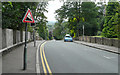
Edge Hill - Steep Hill 12%
Edge Hill, Wimbledon. 12% steep hill down sign.
Image: © Adam Morse
Taken: 4 Aug 2009
0.11 miles
10
Wimbledon College, Edge Hill, Wimbledon.
Jesuit School established 1892.
Image: © Noel Foster
Taken: 18 Jun 2005
0.13 miles