IMAGES TAKEN NEAR TO
Watson Close, LONDON, SW19 2EL
Introduction
This page details the photographs taken nearby to Watson Close, SW19 2EL by members of the Geograph project.
The Geograph project started in 2005 with the aim of publishing, organising and preserving representative images for every square kilometre of Great Britain, Ireland and the Isle of Man.

There are currently over 7.5m images from over14,400 individuals and you can help contribute to the project by visiting https://www.geograph.org.uk
Image Map (Loading...)


Getting Data...Please wait
Leaflet Map data © OpenStreetMap
Images are licensed for reuse under creativecommons.org/licenses/by-sa/2.0
Notes
- Clicking on the map will re-center to the selected point.
- The higher the marker number, the further away the image location is from the centre of the postcode.
Image Listing (21 Images Found)
Images are licensed for reuse under creativecommons.org/licenses/by-sa/2.0
Image
Details
Distance
1
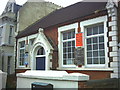
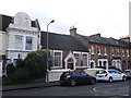
Gospel Hall, Longley Road, Tooting Junction.
Image: © Noel Foster
Taken: 16 Jun 2005
0.01 miles
2
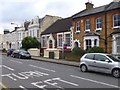
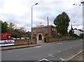
Tooting Junction Baptist Church, Longley Road.
It's the church next to the footbridge over the railway.
Image: © Noel Foster
Taken: 16 Jun 2005
0.01 miles
3
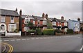
Robinson Road, Colliers Wood
Seen across the junction with Lyveden Road, with an interesting variety of house styles, I would guess dating from around the turn of the C19-C20.
Image: © Derek Harper
Taken: 30 Nov 2009
0.07 miles
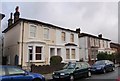
4
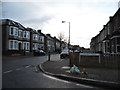
Longley Road at the junction of Charlmont Road
Image: © David Howard
Taken: 22 Mar 2014
0.16 miles
5
Gospel Hall, Tooting
Small church along Longley Road, between rows of terraced housing.
Image: © David Anstiss
Taken: 9 Dec 2012
0.16 miles
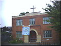
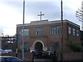
6
Tooting, gospel hall
Longley Road Gospel Hall, dated 1884.
Image: © Mike Faherty
Taken: 23 Nov 2013
0.17 miles
7
Tooting Baptist Church
On Longley Road.
Image: © David Anstiss
Taken: 9 Dec 2012
0.19 miles
8
Villas on Robinson Road, Collier's Wood
Each pair of these semi-detached villas - there are three pairs here, one of which is on the left - has a name. The one in the centre is Lorne Villas, and it was inhabited at the 1881 census, by Joseph Tyler, a jeweller.
Image: © Derek Harper
Taken: 30 Nov 2009
0.19 miles
9
Tooting Junction Baptist Church
On Longley Road, dated 1936: http://www.tjbc.org.uk/
Image: © Mike Faherty
Taken: 23 Nov 2013
0.20 miles
10
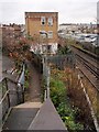
Path and railway track, Tooting
Taken from a footbridge across the railway line about 200 metres west of Tooting Station. Behind the car park are buildings on London Road, the A217. The footpath joins Longley Road. The three-storey block of flats replaced an old railway building on the site.
Image: © Derek Harper
Taken: 30 Nov 2009
0.20 miles