IMAGES TAKEN NEAR TO
Kipling Drive, LONDON, SW19 1TL
Introduction
This page details the photographs taken nearby to Kipling Drive, SW19 1TL by members of the Geograph project.
The Geograph project started in 2005 with the aim of publishing, organising and preserving representative images for every square kilometre of Great Britain, Ireland and the Isle of Man.

There are currently over 7.5m images from over14,400 individuals and you can help contribute to the project by visiting https://www.geograph.org.uk
Image Map (Loading...)


Getting Data...Please wait
Leaflet Map data © OpenStreetMap
Images are licensed for reuse under creativecommons.org/licenses/by-sa/2.0
Notes
- Clicking on the map will re-center to the selected point.
- The higher the marker number, the further away the image location is from the centre of the postcode.
Image Listing (59 Images Found)
Images are licensed for reuse under creativecommons.org/licenses/by-sa/2.0
Image
Details
Distance
1
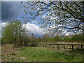
Wandle Meadow Nature Park
This site was originally a sewage works, built in 1877 by the Croydon Board of Health. They became the works of the Wandle Valley Joint Sewerage Board in 1917. The works were closed in the 1970s and the above-ground structures demolished and made safe. Eventually in 1994, Merton Council allowed housing in a small part of the old works to the west of the River Wandle and established Wandle Meadow Nature Park on the rest. Although the clouds looked threatening on this day, the showers never really materialised, at least not where I was.
Image: © Marathon
Taken: 11 Apr 2012
0.06 miles
2
Wandle Meadow Nature Park
This site was originally a sewage works, built in 1877 by the Croydon Board of Health. They became the works of the Wandle Valley Joint Sewerage Board in 1917. The works were closed in the 1970s and the above-ground structures demolished and made safe. Eventually in 1994, Merton Council allowed housing in a small part of the old works to the west of the River Wandle and established Wandle Meadow Nature Park on the rest. Although the clouds looked threatening on this day, the showers never really materialised, at least not where I was.
Image: © Marathon
Taken: 11 Apr 2012
0.06 miles
5
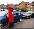
Pillar box, North Road
Edward VII postbox no SW19 108, where the NCN 22 and the Wandle Trail cross North Road.
Image: © Derek Harper
Taken: 30 Nov 2009
0.07 miles
6
South Wimbledon, railway bridge
Taking the Sutton to Blackfriars line over Wandle Meadow Nature Park.
Image: © Mike Faherty
Taken: 23 Nov 2013
0.08 miles
7
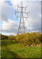
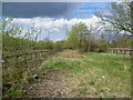
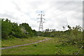
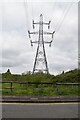
Collier's Wood, power lines
Crossing Wandle Meadow Nature Park.
Image: © Mike Faherty
Taken: 23 Nov 2013
0.09 miles
9
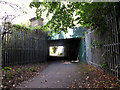
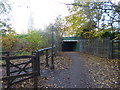
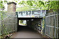
Railway underpass near Haydons Road
The path is part of both the Wandle Trail and NCN 20 at this point. The railway above is part of the Thameslink Wimbledon loop line.
Image: © Stephen Craven
Taken: 29 Aug 2011
0.09 miles