IMAGES TAKEN NEAR TO
East Road, LONDON, SW19 1FW
Introduction
This page details the photographs taken nearby to East Road, SW19 1FW by members of the Geograph project.
The Geograph project started in 2005 with the aim of publishing, organising and preserving representative images for every square kilometre of Great Britain, Ireland and the Isle of Man.

There are currently over 7.5m images from over14,400 individuals and you can help contribute to the project by visiting https://www.geograph.org.uk
Image Map
Images are licensed for reuse under creativecommons.org/licenses/by-sa/2.0
Notes
- Clicking on the map will re-center to the selected point.
- The higher the marker number, the further away the image location is from the centre of the postcode.
Image Listing (119 Images Found)
Images are licensed for reuse under creativecommons.org/licenses/by-sa/2.0
Image
Details
Distance
1
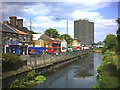
River Wandle at Merton High Street (A238)
"The Tower" in background.
Image: © Noel Foster
Taken: 14 Jun 2005
0.02 miles
3
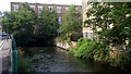
River Wandle, South Wimbledon
Impressively clear water.
Image: © Mike Pennington
Taken: 28 Jul 2015
0.05 miles
4

Memorial fountain in Wandle Park
The drinking fountain is now disused. The inscription on it records a dedication to Harry Ashby and Robert Fenwick and refers to their involvement in the formation of the new parish of All Saints, South Wimbledon Image
Image: © Stephen Craven
Taken: 29 Aug 2011
0.06 miles
5
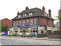
Merton bus garage - eastern elevation
This shows the Wandle Bank entrance to the garage. Given the number of cars usually parked outside it, this entrance is unlikely be in regular use.
Image: © David Kemp
Taken: 1 Nov 2017
0.09 miles
6
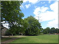
Wandle Park
Wandle Park was once the site of Wandlebank House and grounds. The land was purchased by Wimbledon Corporation for a public park and vested in the National Trust, and the park opened in 1907. In 1910 the Mill Pond Garden was added, purchased by public subscription.
In 2003 the park was redesigned to create more interest, the main feature being the reopening of the old sinuous course of the River Wandle through the park and the creation of a reed bed. The more recent straightened course of the Wandle alongside Wandle Bank still takes much of the flow but the flow in the old course is also substantial. A view of the redesigned river can be seen at https://www.geograph.org.uk/photo/2894734
Image: © Marathon
Taken: 1 Aug 2020
0.10 miles
7

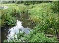
The old course of the River Wandle in Wandle Park
Wandle Park was once the site of Wandlebank House and grounds. The land was purchased by Wimbledon Corporation for a public park and vested in the National Trust, and the park opened in 1907. In 1910 the Mill Pond Garden was added, purchased by public subscription.
In 2003 the park was redesigned to create more interest, the main feature being the reopening of the old sinuous course of the River Wandle through the park and the creation of a reed bed. The more recent straightened course of the Wandle alongside Wandle Bank still takes much of the flow but as seen here the flow in the old course is also substantial.
A view of the river through the park more than eight years later can be seen at https://www.geograph.org.uk/photo/6560972
Image: © Marathon
Taken: 11 Apr 2012
0.10 miles
8
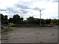
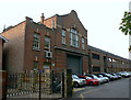
Disused filter beds (2)
Disused filter beds at the former Thames Water sewage treatment works in Merton (closed in 1971).
Image: © Stephen Craven
Taken: 29 Aug 2011
0.11 miles
9
The old course of the River Wandle in Wandle Park
Wandle Park was once the site of Wandlebank House and grounds. The land was purchased by Wimbledon Corporation for a public park and vested in the National Trust, and the park opened in 1907. In 1910 the Mill Pond Garden was added, purchased by public subscription.
In 2003 the park was redesigned to create more interest, the main feature being the reopening of the old sinuous course of the River Wandle through the park and the creation of a reed bed. The more recent straightened course of the Wandle alongside Wandle Bank still takes much of the flow but as seen here the flow in the old course is also substantial. This looks upriver. A clearer view of the redesigned river when there was less vegetation can be seen at https://www.geograph.org.uk/photo/2894734
Image: © Marathon
Taken: 1 Aug 2020
0.11 miles
10
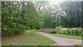
Footbridge in Wandle Park, Collier's Wood
Image: © Mike Pennington
Taken: 28 Jul 2015
0.11 miles