IMAGES TAKEN NEAR TO
Burr Road, LONDON, SW18 4SQ
Introduction
This page details the photographs taken nearby to Burr Road, SW18 4SQ by members of the Geograph project.
The Geograph project started in 2005 with the aim of publishing, organising and preserving representative images for every square kilometre of Great Britain, Ireland and the Isle of Man.

There are currently over 7.5m images from over14,400 individuals and you can help contribute to the project by visiting https://www.geograph.org.uk
Image Map
Images are licensed for reuse under creativecommons.org/licenses/by-sa/2.0
Notes
- Clicking on the map will re-center to the selected point.
- The higher the marker number, the further away the image location is from the centre of the postcode.
Image Listing (34 Images Found)
Images are licensed for reuse under creativecommons.org/licenses/by-sa/2.0
Image
Details
Distance
1
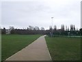
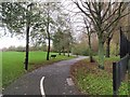
Path to River Wandle, St George's Park
This path leads through the park from Burr Road towards the river and a footbridge leading to Garratt Lane.
On the right is an enclosed football pitch.
Image: © David Anstiss
Taken: 30 Dec 2012
0.05 miles
2
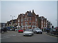
Southfields main crossroads
One of the first photos I took with a digital camera.
Image: © Christopher
Taken: 1 Mar 2004
0.06 miles
3
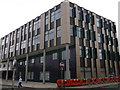
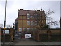
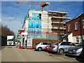
Southfield Community College
A newly constructed reception and rooms, for the college on the junction of Burr Road and Merton Road.
Image: © David Anstiss
Taken: 30 Dec 2012
0.08 miles
4
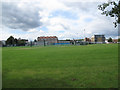
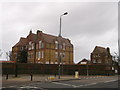
Southfields Community College
The college is a secondary school on Merton Road. Here it is seen from across King George's Park.
Image: © Stephen Craven
Taken: 29 Aug 2011
0.09 miles
5
Riversdale School, Southfields
Entrance to the Grade II listed school. On the junction of Pirbright Road and Replingham Road.
See http://www.britishlistedbuildings.co.uk/en-506995-riversdale-school-with-associated-careta for more details about the listed school.
Image: © David Anstiss
Taken: 30 Dec 2012
0.10 miles
6
Riversdale School with Associated Caretaker's House, Southfields
Grade II listed school and caretaker's house (on the right).
On the junction of Pirbright Road and Replingham Road.
See http://www.britishlistedbuildings.co.uk/en-506995-riversdale-school-with-associated-careta for more details about the listed school.
Image: © David Anstiss
Taken: 30 Dec 2012
0.12 miles
8
Wandle Trail in King George's Park (2)
This path, seen just over 100 metres northeast of the scene in Image, is also called Foster's Way. The palisade metal fence on the right encloses Westfield House, a DTI archiving depot.
Image: © Derek Harper
Taken: 30 Nov 2009
0.14 miles
9
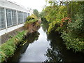
River Wandle
This is the River Wandle between Earlsfield and Wandsworth as seen from the footbridge between Lydden Road and King George's Park. The park is beyond the trees on the right, whilst on the left are industrial premises.
Image: © Marathon
Taken: 5 Oct 2011
0.14 miles
10
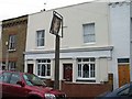
The Builders Arms, Longfield Street, Southfields
The pub has been converted to a private house but the pub sign remains.
Image: © Duncan Grey
Taken: 10 Jan 2010
0.14 miles