IMAGES TAKEN NEAR TO
Iron Mill Road, LONDON, SW18 2AQ
Introduction
This page details the photographs taken nearby to Iron Mill Road, SW18 2AQ by members of the Geograph project.
The Geograph project started in 2005 with the aim of publishing, organising and preserving representative images for every square kilometre of Great Britain, Ireland and the Isle of Man.

There are currently over 7.5m images from over14,400 individuals and you can help contribute to the project by visiting https://www.geograph.org.uk
Image Map
Images are licensed for reuse under creativecommons.org/licenses/by-sa/2.0
Notes
- Clicking on the map will re-center to the selected point.
- The higher the marker number, the further away the image location is from the centre of the postcode.
Image Listing (94 Images Found)
Images are licensed for reuse under creativecommons.org/licenses/by-sa/2.0
Image
Details
Distance
1
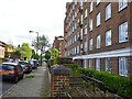
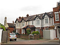
Iron Mill Road, Wandsworth
Domelton House on the right.
Image: © Robin Webster
Taken: 12 May 2012
0.06 miles
2
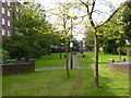
Garden between flat blocks
Bowyer House is on the left, Domelton House on the right.
Image: © Robin Webster
Taken: 12 May 2012
0.08 miles
3
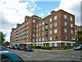
Bowyer House
On the Wendlesworth Estate, London Borough of Wandsworth.
Image: © Robin Webster
Taken: 12 May 2012
0.08 miles
4
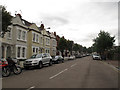
Pentland Street, Wandsworth
A street of terraced houses.
Image: © Stephen Craven
Taken: 20 Jun 2014
0.08 miles
5
Pentland Gardens, Wandsworth
A dead-end street of terraced houses off Pentland Street.
Image: © Stephen Craven
Taken: 20 Jun 2014
0.10 miles
6
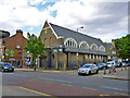
Former church, corner of Iron Mill Place and Garratt Lane
Here Earlsfield Boxing Club.
Image: © Robin Webster
Taken: 12 May 2012
0.10 miles
7
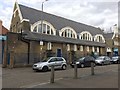
Boxing Club
Earlsfield Amateur Boxing Club.
Image: © Alan Hughes
Taken: 4 Mar 2017
0.11 miles
8
The Old Sergeant Public House, Wandsworth
On 104 Garrett Lane.
Image: © David Anstiss
Taken: 30 Dec 2012
0.12 miles
9
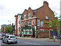
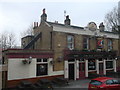
Tir na nOg
Formerly the Horse and Groom, which name is still inscribed in the roundel above the near door. The other roundel gives the date, 1904, and a monogram presumably representing the brewer, involving what looks like T H B and possibly another B (in some order or other). Trueman, Hanbury, Buxton springs to mind. There was a pub of this name at this site before 1904.
Image: © Robin Webster
Taken: 12 May 2012
0.12 miles
10
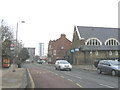
Garratt Lane, Wandsworth
The main road south from Wandsworth town centre, looking north. The building on the right is the former St Mary's church, now a boxing club.
Image: © Stephen Craven
Taken: 30 Jan 2007
0.12 miles