IMAGES TAKEN NEAR TO
Eastfields Avenue, LONDON, SW18 1RD
Introduction
This page details the photographs taken nearby to Eastfields Avenue, SW18 1RD by members of the Geograph project.
The Geograph project started in 2005 with the aim of publishing, organising and preserving representative images for every square kilometre of Great Britain, Ireland and the Isle of Man.

There are currently over 7.5m images from over14,400 individuals and you can help contribute to the project by visiting https://www.geograph.org.uk
Image Map
Images are licensed for reuse under creativecommons.org/licenses/by-sa/2.0
Notes
- Clicking on the map will re-center to the selected point.
- The higher the marker number, the further away the image location is from the centre of the postcode.
Image Listing (236 Images Found)
Images are licensed for reuse under creativecommons.org/licenses/by-sa/2.0
Image
Details
Distance
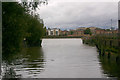
1

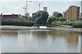
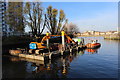
Grass, flowers and bushes by Bell Lane Creek
A footpath usable during daylight hours and skirting a long-standing development site on the east side of Riverside Quarter, now offers this view across the Thames at the mouth of the Wandle. Across the main river are the Piper Building (see Image) and Barton House (Image).
Image: © Derek Harper
Taken: 3 Aug 2012
0.02 miles
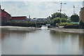
4
The mouth of the River Wandle
The River Wandle splits into two just south of the railway line and converges just before it flows into the River Thames ahead. This is the western branch.
Image: © Marathon
Taken: 1 Sep 2022
0.02 miles
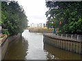
5
Mouth of River Wandle
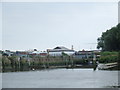
There is a weir at the mouth, intended to have a central moving section that only lowered at higher tide levels, so allowing deep draught vessels to enter when the tide is suitable, yet impounding water at lower tides. Traffic lights controlled navigation over the weir. This has been inoperative for some time, with the weir lowered, so the river is fully tidal. The River Wandle comes from right of the camera, and is only navigable (dependent on the tide) for a very short distance. To the left of the camera is Bell Lane Creek, navigable rather further to Bell Weir south of the railway.
Image: © Robin Webster
Taken: 14 Apr 2012
0.02 miles
6
Mouth of the River Wandle
The River Wandle flows for around 9 miles from a source near Croydon through South London to flow into the River Thames here near Wandsworth.
Image: © Malc McDonald
Taken: 2 Jul 2011
0.02 miles
7
View from the Spit in Wandle creek near the confluence with the Thames
Image: © Roger Davies
Taken: 11 Dec 2016
0.02 miles
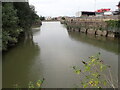
9
River Wandle meets the Thames
This is the end of the River Wandle's 11-mile journey across the South London suburbs. In Victorian times the Wandle was one of the hardest-working rivers in the world, with 90 mills along its length, and water so pure and clear that it attracted prestigious printers like William Morris and Arthur Liberty.
Image: © Mark Percy
Taken: 14 Dec 2022
0.03 miles
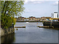
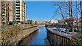
10
Confluence of River Wandle with the Thames
Taken from The Causeway bridge. This was the first time I'd seen the mouth of the Wandle seemingly clear of obstructions.
Image: © David Kemp
Taken: 7 Oct 2017
0.03 miles