IMAGES TAKEN NEAR TO
Balham High Road, LONDON, SW17 7BQ
Introduction
This page details the photographs taken nearby to Balham High Road, SW17 7BQ by members of the Geograph project.
The Geograph project started in 2005 with the aim of publishing, organising and preserving representative images for every square kilometre of Great Britain, Ireland and the Isle of Man.

There are currently over 7.5m images from over14,400 individuals and you can help contribute to the project by visiting https://www.geograph.org.uk
Image Map
Images are licensed for reuse under creativecommons.org/licenses/by-sa/2.0
Notes
- Clicking on the map will re-center to the selected point.
- The higher the marker number, the further away the image location is from the centre of the postcode.
Image Listing (206 Images Found)
Images are licensed for reuse under creativecommons.org/licenses/by-sa/2.0
Image
Details
Distance
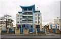
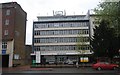
2

Lumiere Court
Strikingly modern block of flats on the south side of Balham High Road, much different in style from any of its neighbours. Note the incongruous advert for salsa and the milk float in the foreground.
Image: © Colin Smith
Taken: 19 Oct 2008
0.02 miles
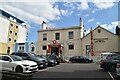
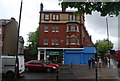
3
Lumiere Court, Balham Spirtualist Church and Hamilton House
Diverse buildings in Balham High Road. Hamilton House, on the right, is one of only two survivors of a row of large Victorian villas marked on the 1875 25 inch map. It was marked on most maps as a constitutional club and currently houses the White Eagle Club, a Polish community centre. In a previous guise the building housed the 211 Club in the 1950s/60s, a vice den linked to the gangster Kray twins. Grade II listed - see https://historicengland.org.uk/listing/the-list/list-entry/1357625?section=official-list-entry. The other survivor of the original villas, Swan House (formerly Mansbridge House), is partly visible on the far left of the photo. Also grade II listed - see https://historicengland.org.uk/listing/the-list/list-entry/1065579?section=official-list-entry - it now houses an independent school and is also grade II listed.
The annexe to Hamilton House, in the centre of the photo, houses Balham Spiritualist Church.
Lumiere Court, on the left, is an apartment block completed in 2002.
Image: © Ian Capper
Taken: 7 Oct 2022
0.02 miles
4
Lumiere Court, Balham
Another view of Image, which was built in 2001, from across Balham High Road.
Image: © Derek Harper
Taken: 13 Jan 2011
0.03 miles
6
Bedford House, Balham High Rd
Offices containing several of Wandsworth services.
Image: © N Chadwick
Taken: 8 May 2010
0.04 miles

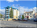
9
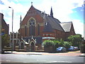
Polish RC Church, Balham High Road.
Kosciól Chrystusa Króla, which translates as Christ the King.
Image: © Noel Foster
Taken: 20 Jul 2005
0.05 miles
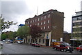
10
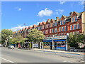
The Boulevard
Terrace of late 19th Century shops/houses on Balham High Road, first shown on the 1916 25 inch map, replacing part of a row of large Victorian villas marked on the 1875 and 1897 editions (see Image for nearby Hamilton House, on of two survivors of these earlier villas). The 1921 1:1056 plan names the row of shops "Boulevard Mansions". This shows the terrace to have been set back from the road, suggesting that the shops were a later addition, extending forward the ground floor of the terrace. This would appear to be confirmed by the 1950 1:1250 plan, which is also where the terrace is first marked as "The Boulevard", consistent with a change of usage from purely housing.
Image: © Ian Capper
Taken: 7 Oct 2022
0.05 miles