Lumiere Court, Balham Spirtualist Church and Hamilton House
Introduction
The photograph on this page of Lumiere Court, Balham Spirtualist Church and Hamilton House by Ian Capper as part of the Geograph project.
The Geograph project started in 2005 with the aim of publishing, organising and preserving representative images for every square kilometre of Great Britain, Ireland and the Isle of Man.

There are currently over 7.5m images from over 14,400 individuals and you can help contribute to the project by visiting https://www.geograph.org.uk
Lumiere Court, Balham Spirtualist Church and Hamilton House
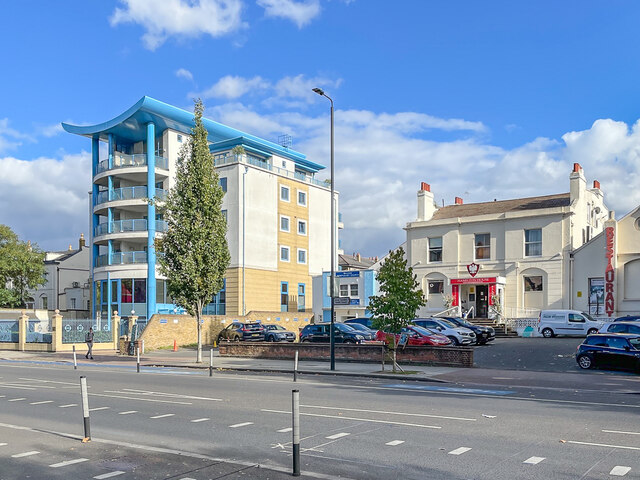
Image: © Ian Capper Taken: 7 Oct 2022
Diverse buildings in Balham High Road. Hamilton House, on the right, is one of only two survivors of a row of large Victorian villas marked on the 1875 25 inch map. It was marked on most maps as a constitutional club and currently houses the White Eagle Club, a Polish community centre. In a previous guise the building housed the 211 Club in the 1950s/60s, a vice den linked to the gangster Kray twins. Grade II listed - see https://historicengland.org.uk/listing/the-list/list-entry/1357625?section=official-list-entry. The other survivor of the original villas, Swan House (formerly Mansbridge House), is partly visible on the far left of the photo. Also grade II listed - see https://historicengland.org.uk/listing/the-list/list-entry/1065579?section=official-list-entry - it now houses an independent school and is also grade II listed. The annexe to Hamilton House, in the centre of the photo, houses Balham Spiritualist Church. Lumiere Court, on the left, is an apartment block completed in 2002.
Images are licensed for reuse under creativecommons.org/licenses/by-sa/2.0
Image Location
Latitude
51.439921
Longitude
-0.155162