IMAGES TAKEN NEAR TO
Aldis Street, LONDON, SW17 0RZ
Introduction
This page details the photographs taken nearby to Aldis Street, SW17 0RZ by members of the Geograph project.
The Geograph project started in 2005 with the aim of publishing, organising and preserving representative images for every square kilometre of Great Britain, Ireland and the Isle of Man.

There are currently over 7.5m images from over14,400 individuals and you can help contribute to the project by visiting https://www.geograph.org.uk
Image Map
Images are licensed for reuse under creativecommons.org/licenses/by-sa/2.0
Notes
- Clicking on the map will re-center to the selected point.
- The higher the marker number, the further away the image location is from the centre of the postcode.
Image Listing (68 Images Found)
Images are licensed for reuse under creativecommons.org/licenses/by-sa/2.0
Image
Details
Distance
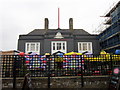
1
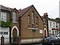
Pentecostal church, Aldis Street
Believed to date from the 1870s, this was originally the Aldis Street Mission of St Nicholas's parish. As of 2008 it was the Pilgrims Union Pentecostal Church of God.
Image: © Stephen Craven
Taken: 26 Aug 2008
0.03 miles
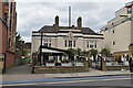
3
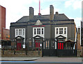
Trafalgar Arms, Tooting High Street
When this photo was taken the pub was closed and a developer wanted to pull it down and build some flats, all very predictable. However, amid local opposition, the pub has since re-opened. Period lettering survives advertising Hodgson's Kingston Ale and Stout.
Image: © Stephen Richards
Taken: 22 Mar 2015
0.05 miles
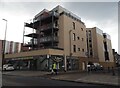
8
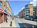
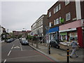
Tooting High Street
Looking along Tooting High Street with a late 19th Century parade of shops/flats on the left and a c.2010 redevelopment on the right. This section of Tooting High Street was named Merton Road on the 1897 25 inch map.
Image: © Ian Capper
Taken: 7 Oct 2022
0.06 miles
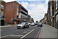
9
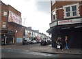
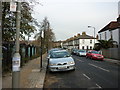
Selkirk Road at the junction of Tooting High Street
Image: © David Howard
Taken: 5 Jul 2018
0.06 miles