IMAGES TAKEN NEAR TO
Garratt Lane, LONDON, SW17 0NU
Introduction
This page details the photographs taken nearby to Garratt Lane, SW17 0NU by members of the Geograph project.
The Geograph project started in 2005 with the aim of publishing, organising and preserving representative images for every square kilometre of Great Britain, Ireland and the Isle of Man.

There are currently over 7.5m images from over14,400 individuals and you can help contribute to the project by visiting https://www.geograph.org.uk
Image Map (Loading...)


Getting Data...Please wait
Leaflet Map data © OpenStreetMap
Images are licensed for reuse under creativecommons.org/licenses/by-sa/2.0
Notes
- Clicking on the map will re-center to the selected point.
- The higher the marker number, the further away the image location is from the centre of the postcode.
Image Listing (32 Images Found)
Images are licensed for reuse under creativecommons.org/licenses/by-sa/2.0
Image
Details
Distance
1
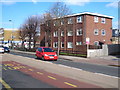
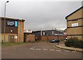
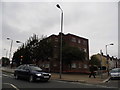
697 Garratt Lane Earlsfield
A late 1960s block of flats on the corner of Burntwood Lane.
Image: © Rod Allday
Taken: 6 Mar 2010
0.05 miles
2
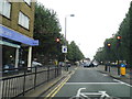
Garratt Lane at the junction of Burntwood Lane
Image: © David Howard
Taken: 29 Sep 2013
0.05 miles
3
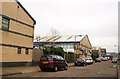
Business units, Maskell Road, Summerstown
Modern units on the Elms Industrial Estate sector of Garratt Business Park along the south side of Maskell Road, opposite a housing development.
Image: © Derek Harper
Taken: 7 Feb 2010
0.09 miles
4
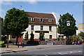
The Leather Bottle
A Young's pub on Garratt Lane, near Garratt Park.
Image: © Bill Boaden
Taken: 30 Jul 2011
0.12 miles
5
Garratt Business Park
Units by St Martins Way on the estate. The units on the left and the right form part of the Elms Industrial Estate, while the garage is in the Swan Centre.
Image: © Derek Harper
Taken: 7 Feb 2010
0.13 miles
6
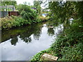
River Wandle from the Wandle Trail
The section of the Wandle Trail alongside the River Wandle between Trewint Street bridge and Plough Lane is largely surrounded by light industry as well as some allotments. Unfortunately, there is also a fair amount of dumped rubbish, especially in this northern section. This view looks across the river to the northern edge of the allotments alongside Garratt Park.
Image: © Marathon
Taken: 5 Oct 2011
0.14 miles
7
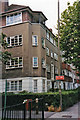
Block of Flats in Burntwood Lane, SW17
This block of flats was built on the site of The Red House, 64 Burntwood Lane, Image
following the demolition of that house in the mid 1930's, when it was sold following the death of the owner, William Pinnell.
Image: © Christine Matthews
Taken: 15 Jul 1999
0.15 miles
8
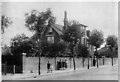
The Red House, 64 Burntwood Lane, Earlsfield, London SW17
The Red House used to be at No. 64 Burntwood Lane, Earlsfield, adjacent to Garratt Green. Following the death in 1935 of the owner, William Pinnell, Image], the house was sold. William can be seen in the picture by the gate; the other people on the pavement are his children and grandchildren. The house was demolished in the late 1930s and a block of flats was built, which is still there now Image
This photograph was taken by William Pinnell's son, William Thomas Pinnell, who was a trained photographer, who died in 1959.
Image: © William Thomas Pinnell
Taken: Unknown
0.15 miles
9
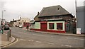
Summerstown
The confidently-decorated Carlos Cafe across the road abuts the Gothic House. On the left is the Prince of Wales pub, built in 1898 to replace an 1852 building on the site of the Surrey Iron Railway http://www.youngs.co.uk/pub-detail.asp?PubID=316 . Seen from the junction with Riverside Road.
Image: © Derek Harper
Taken: 7 Feb 2010
0.16 miles
10
Flats on the corner of Garratt Lane and Burmester Road
Image: © David Howard
Taken: 29 Sep 2013
0.17 miles