IMAGES TAKEN NEAR TO
Kenlor Road, LONDON, SW17 0DG
Introduction
This page details the photographs taken nearby to Kenlor Road, SW17 0DG by members of the Geograph project.
The Geograph project started in 2005 with the aim of publishing, organising and preserving representative images for every square kilometre of Great Britain, Ireland and the Isle of Man.

There are currently over 7.5m images from over14,400 individuals and you can help contribute to the project by visiting https://www.geograph.org.uk
Image Map
Images are licensed for reuse under creativecommons.org/licenses/by-sa/2.0
Notes
- Clicking on the map will re-center to the selected point.
- The higher the marker number, the further away the image location is from the centre of the postcode.
Image Listing (64 Images Found)
Images are licensed for reuse under creativecommons.org/licenses/by-sa/2.0
Image
Details
Distance
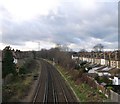
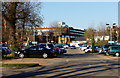
2
Railway to Tooting
As seen from Image
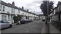
The houses on the left are along Kenlor Road.
In the background is the A24 road bridge between Tooting and Collier's Street.
Image: © David Anstiss
Taken: 9 Dec 2012
0.02 miles
3
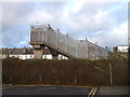
Footbridge on Boundary Road
This bridge leads to Kenlor Road, with a path to Blackshaw Road (and St George's Hospital).
It passes over the railway line between Tooting and Hayden's Road.
Image: © David Anstiss
Taken: 9 Dec 2012
0.03 miles
4
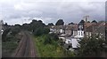
Colliers Wood - Overground Railway Line
Wimbledon to Tooting line Thameslink.
Thameslink mainline wikipedia : https://en.wikipedia.org/wiki/Thameslink
Image: © James Emmans
Taken: 28 Aug 2016
0.04 miles
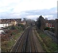
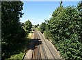
5
Railway to Hayden's Road
As seen from Image
The houses on the right are along Kenlor Road.
Image: © David Anstiss
Taken: 9 Dec 2012
0.05 miles
7
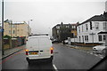
Queuing traffic on Blackshaw Road
It takes a long time to get onto Tooting High Street ahead, as the traffic lights give very little opportunity to move at each change.
Image: © Bill Boaden
Taken: 13 Sep 2013
0.07 miles
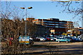
8
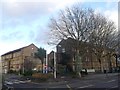
St George's Hospital, Tooting
Originally The Grove Fever and Fountain Hospitals, before being merged into St George's in 1954.
Now one of the UK's largest teaching hospitals.
Image: © David Anstiss
Taken: 9 Dec 2012
0.07 miles
9
St.George's Hospital, Tooting
Looking across the public car park, from Blackshaw Road.
Image: © Peter Trimming
Taken: 25 Feb 2012
0.07 miles
10
St.George's Hospital, Tooting
View across the public car park, from Blackshaw Road.
Image: © Peter Trimming
Taken: 25 Feb 2012
0.07 miles