1
Detail of 322 Streatham High Road
A decorative plaque recording the Hill Bros, local speculative builders, Broadway, the original name of the parade of shops, and the date 1884.
A full view of the whole group can be seen here:
Image]
Image: © Stephen Richards
Taken: Unknown
0.03 miles
2
Streatham High Road, London, SW16
Image: © Stacey Harris
Taken: 8 Nov 2008
0.03 miles
3
Information board on Streatham Green
This notice gives the history of Streatham Green and the Dyce Fountain.
Image: © Marathon
Taken: 3 Sep 2010
0.04 miles
4
Streatham High Road
As well as being a comprehensive local shopping street, Streatham High Road is also a trunk road, the A23 London-to-Brighton road. The view is looking north.
Photo number 7589809.
Image: © Robin Stott
Taken: 2 Sep 2023
0.05 miles
5
Detail of 310 Streatham High Road
A closer view of the decorative plasterwork, and decorative brick panels under the windows. Both are well above eye-level so unlikely to be spotted by most people. It looks as if this building has recently been cleaned and renovated.
A full view of the whole group can be seen here:
Image]
Image: © Stephen Richards
Taken: Unknown
0.05 miles
6
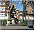
Drinking Fountain, Streatham High Road
Situated on the Green between the High Road and Mitcham Lane, the red and white stone Gothic fountain was designed in 1862 by the artist, William Dyce, who lived locally. It was moved from the junction of the two roads to its present location in the 1930s when the High Road was widened. The inscription reads, "For I will pour water on him that thirsts." The Green has recently been renovated and one of the trendy new seats can be seen on the right. The outdoor drinkers can now luxuriate in style. It is within the Streatham High Road and Streatham Hill Conservation Area.
The course of Streatham High Road has been a major highway between London and Sussex since Roman times. Its current appearance is largely attributable to two major spells of development. The first was during the late C19th following the opening of Streatham Hill station in 1856, and the second was after 1911 when the line to Victoria was electrified. Though much-maligned and undoubtedly blighted by heavy traffic, closer examination reveals that the road is lined with a number of interesting buildings, some of which reflect the period between the wars when Streatham was a fashionable centre of entertainment. Information from Lambeth Council (http://www.lambeth.gov.uk/NR/exeres/CE4B5CE1-0387-40ED-B5A9-273A5160C34A.htm ).
Image: © Stephen Richards
Taken: Unknown
0.05 miles
7
Manor Arms, Mitcham Lane
On the corner of Babington Road, built c1920 on the site of a mansion, Manor Park House. The ground floor has faience pilasters and is surmounted by a shallow dome. It is within the Streatham High Road and Streatham Hill Conservation Area.
Information from Lambeth Council (http://www.lambeth.gov.uk/NR/exeres/CE4B5CE1-0387-40ED-B5A9-273A5160C34A.htm ).
Sorry lady, you just weren't quick enough.
Image: © Stephen Richards
Taken: Unknown
0.05 miles
8
292-322 Streatham High Road
This long terrace of c1883 sweeps round into Gleneagle Road. It is of red brick with shaped gables, some brick decoration such as window aprons, but without the stone bands or painted brick evident elsewhere on the High Road. It was probably designed by Frederick Wheeler. It is within the Streatham High Road and Streatham Hill Conservation Area.
The course of Streatham High Road has been a major highway between London and Sussex since Roman times. Its current appearance is largely attributable to two major spells of development. The first was during the late C19th following the opening of Streatham Hill station in 1856, and the second was after 1911 when the line to Victoria was electrified. Though much-maligned and undoubtedly blighted by heavy traffic, closer examination reveals that the road is lined with a number of interesting buildings, some of which reflect the period between the wars when Streatham was a fashionable centre of entertainment. Information from Lambeth Council (http://www.lambeth.gov.uk/NR/exeres/CE4B5CE1-0387-40ED-B5A9-273A5160C34A.htm ).
Image: © Stephen Richards
Taken: Unknown
0.05 miles
9
Detail of 292 Streatham High Road
A plaque under the dormer window recording the name J.W.R. Rowsley, presumably the builder. It looks as if the building hasn't seen a lick of paint since being built in 1883.
A full view of the whole group can be seen here:
Image]
Image: © Stephen Richards
Taken: Unknown
0.05 miles
10
5-9 Mitcham Lane
A short group of late Victorian shops. It is within the Streatham High Road and Streatham Hill Conservation Area.
Information from Lambeth Council (http://www.lambeth.gov.uk/NR/exeres/CE4B5CE1-0387-40ED-B5A9-273A5160C34A.htm ).
Image: © Stephen Richards
Taken: Unknown
0.05 miles


