IMAGES TAKEN NEAR TO
Woodmansterne Road, LONDON, SW16 5UA
Introduction
This page details the photographs taken nearby to Woodmansterne Road, SW16 5UA by members of the Geograph project.
The Geograph project started in 2005 with the aim of publishing, organising and preserving representative images for every square kilometre of Great Britain, Ireland and the Isle of Man.

There are currently over 7.5m images from over14,400 individuals and you can help contribute to the project by visiting https://www.geograph.org.uk
Image Map
Images are licensed for reuse under creativecommons.org/licenses/by-sa/2.0
Notes
- Clicking on the map will re-center to the selected point.
- The higher the marker number, the further away the image location is from the centre of the postcode.
Image Listing (18 Images Found)
Images are licensed for reuse under creativecommons.org/licenses/by-sa/2.0
Image
Details
Distance
1
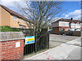
Access for the Agency
The metal gate is where maintenance teams from the Environment Agency can get down safely into the concrete channel of the River Graveney.
The river has just emerged from a longish culvert under a railway embankment which needs to be regularly inspected and kept clear.
Image: © Des Blenkinsopp
Taken: 31 Mar 2015
0.05 miles
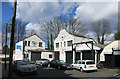
2
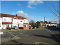
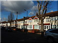
Glenister Park Road Junction with Sherwood Avenue
Image: © James Emmans
Taken: 17 Feb 2017
0.11 miles
3
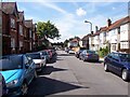
Glencairn Road, Streatham
Looking towards the railway bridge
Image: © Stuart Fisher
Taken: 23 Aug 2005
0.15 miles
6
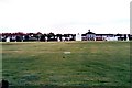
NatWest sports ground Norbury
Opened in 1900 as the London and Westminster Bank sports club.
The bank vacated the ground in 1998 and the 28 acres it occupied recently appears to be in bad condition when viewed from Google Earth.
Shame, as read on.
I had the pleasure of captaining one of the seven regular Saturday sides for a number of years in the 70's, all whom could be accommodated on the same ground at the same time.
Halcyon days - we were the only side to have marmite (by request) on our tea table. Players fought to gain a place in our side for the last match of the year as despite the excellent catering during and after matches we had the pleasure of hosting our own curry club courtesy of a couple of our Indian players. Most reckoned given the strength of the curry Hasu (Mistry) and Sid (Siddiquie) had commenced cooking it at the start of the season.
At one time it was Surrey's 2nd XI ground.
The square immediately in front of the pavilion was probably one of the flattest tracks anywhere in the country, courtesy of the Second World War. The reason being it was laid on a former gun emplacement which was six foot down and drained very quickly.
Image: © Richard Hoare
Taken: Unknown
0.18 miles
7
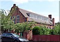
Former church hall, Guildersfield Road
Designed by Ernest George and Alfred Yeates, 1898. George lived locally and his firm built a lot in the area. They used a lot of Dutch motifs, witness the prominent gable here. Grade II listed.
The hall is adjacent to the former vicarage to St Andrew's Church (also by George) which stood to the south-west of the vicarage until it was gutted by fire in 1992 and subsequently demolished (replaced by new housing). The former church hall now houses a GPs' practce.
Image: © Stephen Richards
Taken: 8 Aug 2009
0.18 miles
8
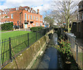
The River Graveney
A tributary of the River Wandle, this stream has just undergone a name change.
Upstream of the culvert seen mid shot here, it's called the Norbury Brook.
A classic urban river in a dismal concrete trench, it has fared better than some others in that it is still above ground.
http://en.wikipedia.org/wiki/Norbury_Brook
Image: © Des Blenkinsopp
Taken: 31 Mar 2015
0.19 miles
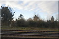
9
Busybean Works
Old industrial premises next to the railway.
Image: © Des Blenkinsopp
Taken: 31 Mar 2015
0.21 miles
10
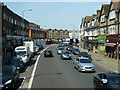
London Road, Norbury (A23)
There is a change of name at the River Graveney bridge, just before the bend. Thereafter the A23 is Streatham High Road.
Image: © Robin Webster
Taken: 19 Apr 2019
0.23 miles