IMAGES TAKEN NEAR TO
Woodmansterne Road, LONDON, SW16 5TY
Introduction
This page details the photographs taken nearby to Woodmansterne Road, SW16 5TY by members of the Geograph project.
The Geograph project started in 2005 with the aim of publishing, organising and preserving representative images for every square kilometre of Great Britain, Ireland and the Isle of Man.

There are currently over 7.5m images from over14,400 individuals and you can help contribute to the project by visiting https://www.geograph.org.uk
Image Map
Images are licensed for reuse under creativecommons.org/licenses/by-sa/2.0
Notes
- Clicking on the map will re-center to the selected point.
- The higher the marker number, the further away the image location is from the centre of the postcode.
Image Listing (24 Images Found)
Images are licensed for reuse under creativecommons.org/licenses/by-sa/2.0
Image
Details
Distance
1
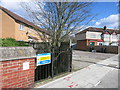
Access for the Agency
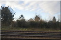
The metal gate is where maintenance teams from the Environment Agency can get down safely into the concrete channel of the River Graveney.
The river has just emerged from a longish culvert under a railway embankment which needs to be regularly inspected and kept clear.
Image: © Des Blenkinsopp
Taken: 31 Mar 2015
0.02 miles
2
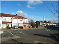
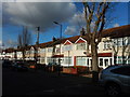
Glenister Park Road Junction with Sherwood Avenue
Image: © James Emmans
Taken: 17 Feb 2017
0.13 miles
3
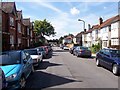
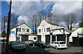
Glencairn Road, Streatham
Looking towards the railway bridge
Image: © Stuart Fisher
Taken: 23 Aug 2005
0.13 miles
4
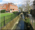
The River Graveney
A tributary of the River Wandle, this stream has just undergone a name change.
Upstream of the culvert seen mid shot here, it's called the Norbury Brook.
A classic urban river in a dismal concrete trench, it has fared better than some others in that it is still above ground.
http://en.wikipedia.org/wiki/Norbury_Brook
Image: © Des Blenkinsopp
Taken: 31 Mar 2015
0.15 miles
6
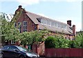
Former church hall, Guildersfield Road
Designed by Ernest George and Alfred Yeates, 1898. George lived locally and his firm built a lot in the area. They used a lot of Dutch motifs, witness the prominent gable here. Grade II listed.
The hall is adjacent to the former vicarage to St Andrew's Church (also by George) which stood to the south-west of the vicarage until it was gutted by fire in 1992 and subsequently demolished (replaced by new housing). The former church hall now houses a GPs' practce.
Image: © Stephen Richards
Taken: 8 Aug 2009
0.17 miles
8
Busybean Works
Old industrial premises next to the railway.
Image: © Des Blenkinsopp
Taken: 31 Mar 2015
0.18 miles
9
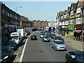
London Road, Norbury (A23)
There is a change of name at the River Graveney bridge, just before the bend. Thereafter the A23 is Streatham High Road.
Image: © Robin Webster
Taken: 19 Apr 2019
0.19 miles
10
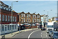
Flats, Streatham High Road (A23)
Unusually a substantial wall in front of them, probably added later.
Image: © Robin Webster
Taken: 19 Apr 2019
0.19 miles