IMAGES TAKEN NEAR TO
Ambleside Avenue, LONDON, SW16 1QP
Introduction
This page details the photographs taken nearby to Ambleside Avenue, SW16 1QP by members of the Geograph project.
The Geograph project started in 2005 with the aim of publishing, organising and preserving representative images for every square kilometre of Great Britain, Ireland and the Isle of Man.

There are currently over 7.5m images from over14,400 individuals and you can help contribute to the project by visiting https://www.geograph.org.uk
Image Map
Images are licensed for reuse under creativecommons.org/licenses/by-sa/2.0
Notes
- Clicking on the map will re-center to the selected point.
- The higher the marker number, the further away the image location is from the centre of the postcode.
Image Listing (182 Images Found)
Images are licensed for reuse under creativecommons.org/licenses/by-sa/2.0
Image
Details
Distance

2
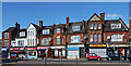
10-24 Mitcham Lane
A group of 1891 in a Queen Anne revival style, for example, see the pargetting in the gables. It is within the Streatham High Road and Streatham Hill Conservation Area.
Information from Lambeth Council (http://www.lambeth.gov.uk/NR/exeres/CE4B5CE1-0387-40ED-B5A9-273A5160C34A.htm ).
Image: © Stephen Richards
Taken: Unknown
0.09 miles
3

St Leonard's Church of England School, Streatham Park
On Mitcham Lane.
Image: © David Anstiss
Taken: 9 Dec 2012
0.09 miles

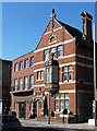
5
Former Fire Station, Mitcham Lane
Probably designed c1903 by the London County Council with Owen Fleming in charge. A handsome building of red brick with stone bands, a segmental pediment and sweeping mansard roof. The fire door survives. On the right are later garage doors built after the right half of the building was destroyed by a bomb on 17th October 1940, killing twelve firemen. It ceased being a fire station in 1971 and is now the South London Islamic Centre. It is within the Streatham High Road and Streatham Hill Conservation Area.
Information from Lambeth Council (http://www.lambeth.gov.uk/NR/exeres/CE4B5CE1-0387-40ED-B5A9-273A5160C34A.htm ).
Image: © Stephen Richards
Taken: Unknown
0.09 miles
6
English Martyr's Presbytery, Mitcham Lane
Next to the church, early C20th in an Arts and Crafts-style. It echoes many of the motifs widely employed on Streatham High Road. Grade II listed. Next door is the 1930s parish hall. Both are within the Streatham High Road and Streatham Hill Conservation Area.
Information from Lambeth Council (http://www.lambeth.gov.uk/NR/exeres/CE4B5CE1-0387-40ED-B5A9-273A5160C34A.htm ).
Image: © Stephen Richards
Taken: Unknown
0.09 miles
7
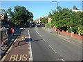
Church on Mitcham Lane, Streatham, viewed from the edge of Tooting Bec Common
Looking east-southeast from beside Tooting Bec Road.
Image: © Robert Lamb
Taken: 20 Jul 2011
0.09 miles
8
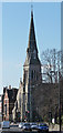
Church of the English Martyrs, Mitcham Lane
A large ragstone church built by A.E. Purdie in 1892 in a French Gothic style. It has a fine broach spire (136 feet). Grade II listed. It is within the Streatham High Road and Streatham Hill Conservation Area.
Information from Lambeth Council (http://www.lambeth.gov.uk/NR/exeres/CE4B5CE1-0387-40ED-B5A9-273A5160C34A.htm ).
Image: © Stephen Richards
Taken: Unknown
0.10 miles
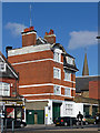
9
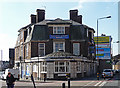
Manor Arms, Mitcham Lane
On the corner of Babington Road, built c1920 on the site of a mansion, Manor Park House. The ground floor has faience pilasters and is surmounted by a shallow dome. It is within the Streatham High Road and Streatham Hill Conservation Area.
Information from Lambeth Council (http://www.lambeth.gov.uk/NR/exeres/CE4B5CE1-0387-40ED-B5A9-273A5160C34A.htm ).
Sorry lady, you just weren't quick enough.
Image: © Stephen Richards
Taken: Unknown
0.10 miles