IMAGES TAKEN NEAR TO
Ellisfield Drive, LONDON, SW15 4DR
Introduction
This page details the photographs taken nearby to Ellisfield Drive, SW15 4DR by members of the Geograph project.
The Geograph project started in 2005 with the aim of publishing, organising and preserving representative images for every square kilometre of Great Britain, Ireland and the Isle of Man.

There are currently over 7.5m images from over14,400 individuals and you can help contribute to the project by visiting https://www.geograph.org.uk
Image Map
Images are licensed for reuse under creativecommons.org/licenses/by-sa/2.0
Notes
- Clicking on the map will re-center to the selected point.
- The higher the marker number, the further away the image location is from the centre of the postcode.
Image Listing (105 Images Found)
Images are licensed for reuse under creativecommons.org/licenses/by-sa/2.0
Image
Details
Distance

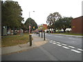
2
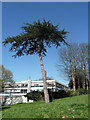
Tree, Roehampton Lane
Probably a pine of some description.
Roehampton was a favoured area for country villas (an unusually high proportion of which survive), and, despite extensive modern development, many fine mature trees from their grounds have been preserved.
Image: © Stephen Richards
Taken: 26 Mar 2012
0.05 miles
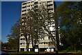
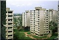
3
Alton West Estate, Roehampton, 1966 ? 1
Image: © Alan Murray-Rust
Taken: 25 Apr 1966
0.06 miles
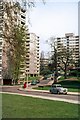
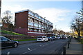
4

Alton West Estate, Danebury Avenue
One of the most highly regarded post-war housing estates, chiefly due to the variation in building types, landscaping and the generous allowance made for green space. The London County Council began planning in 1951 (chief architect Robert Matthew). Alton East came first, Alton West from 1954. Seen here is a group of point blocks and, nearest to the camera, one of the lower maisonette blocks.
Highly regarded by architectural commentators at least - the views of residents are less certain.
Image: © Stephen Richards
Taken: 26 Mar 2012
0.06 miles
5
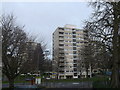
Road junction on Danebury Avenue
As seen from Laverstoke Gardens.
In the background is Wheatley House of the Tangley Grove Estate.
Image: © David Anstiss
Taken: 30 Dec 2012
0.07 miles
7
Danebury Avenue at the corner of Tangley Grove
Image: © David Howard
Taken: 28 Sep 2014
0.07 miles
8
Alton West Estate, Roehampton, 1966 ? 9
Image: © Alan Murray-Rust
Taken: 25 Apr 1966
0.07 miles
10
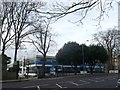
166 Roehampton Lane, Putney Heath
Used by Citizens Advice Centre, South Thames College, and a Surestart children's daycare centre.
Image: © David Anstiss
Taken: 30 Dec 2012
0.08 miles