IMAGES TAKEN NEAR TO
Mercier Road, LONDON, SW15 2AP
Introduction
This page details the photographs taken nearby to Mercier Road, SW15 2AP by members of the Geograph project.
The Geograph project started in 2005 with the aim of publishing, organising and preserving representative images for every square kilometre of Great Britain, Ireland and the Isle of Man.

There are currently over 7.5m images from over14,400 individuals and you can help contribute to the project by visiting https://www.geograph.org.uk
Image Map
Images are licensed for reuse under creativecommons.org/licenses/by-sa/2.0
Notes
- Clicking on the map will re-center to the selected point.
- The higher the marker number, the further away the image location is from the centre of the postcode.
Image Listing (162 Images Found)
Images are licensed for reuse under creativecommons.org/licenses/by-sa/2.0
Image
Details
Distance
1
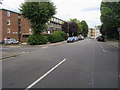
Carlton Drive
Carlton Drive passing Mercier Road
Image: © Shaun Ferguson
Taken: 10 Jul 2009
0.06 miles
2
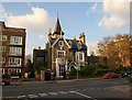
Rosslyn Tower, Putney
This curiosity on St John's Avenue dates from the 1870s, and is described as "a brick and stone building of irregular plan covered with a series of steeply pitched and gabled roofs which, together with chimney stacks and pots (some in Tudor style) break the top of the building into an asymmetrical skyline which is dominated by a 4-storey tower to the rear capped by a pointed slate roof" http://www.imagesofengland.org.uk/Details/Default.aspx?id=207131&mode=adv . "The drawing room was redesigned by Leonard Wyburd RA, who launched Liberty's furnishing and decoration studio." http://www.independent.co.uk/life-style/property-with-cellars-1295427.html .
Image: © Derek Harper
Taken: 14 Apr 2010
0.10 miles
3
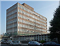
85 Upper Richmond Road
Aka Carlton House. One of a number of post-war office blocks lining this stretch of the road. This one probably dates from the 1970s.
Now occupied by Voluntary Service Overseas.
Image: © Stephen Richards
Taken: 13 Mar 2012
0.12 miles
4
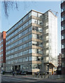
113-123 Upper Richmond Road
One of a number of post-war office blocks lining this stretch of the road. This one probably dates from the 1970s.
Image: © Stephen Richards
Taken: 13 Mar 2012
0.12 miles
5
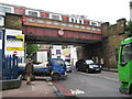
Putney: A205 South Circular Road
In true GCSE examination style compare and contrast this with Image! To the stranger the names South and North Circular Roads might imply a sense of commonality, but...
I can do no better than quote from the opening lines of the excellent SABRE http://www.sabre-roads.org.uk/ website's description of the A205:
"Welcome to the largest collection of signposts in the country. London’s South Circular Road, unlike its northern counterpart, is not so much a coherent through route, more an intricate series of one way systems linked by short lengths of suburban streets. Route-finding is a nightmare, with odd turnings down unlikely-looking side streets occurring when you least expect them. Very few people attempt (still less achieve) the journey end-to-end – it is usually quicker, despite the extra distance, to use the North Circular Road, or just to go straight through the middle of London! Most regular drivers in South London have go-arounds using quiet back streets to avoid the worst stretches – most of these (including mine!) are jealously guarded secrets."
Here, not only is the road narrow, but it passes under the 15' 0" height restriction of London Underground's District Line bridge next to East Putney station.
Between East Putney station and the Fulham Railway Bridge the District Line railway passes over 5 roads each with a distinctive metal box bridge. See
Image
Image
Image
Image
for the others.
Image: © Nigel Cox
Taken: 28 May 2008
0.13 miles
6
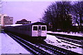
Snow at East Putney
A train on London Underground's District Line leaving East Putney station heading to Wimbledon, in snow.
Image: © Malc McDonald
Taken: 9 Feb 1986
0.13 miles
7
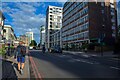
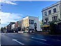
Putney : Upper Richmond Road A205
Looking along Upper Richmond Road.
Image: © Lewis Clarke
Taken: 27 Jun 2022
0.13 miles
8
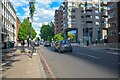
Putney : Upper Richmond Road A205
Looking along Upper Richmond Road.
Image: © Lewis Clarke
Taken: 27 Jun 2022
0.13 miles
10
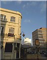
Prince of Wales, Putney
Also shown in Image This view of the gastropub on the corner of Upper Richmond Road (right) and Oxford Road includes blocks of flats on the far side of the former.
Image: © Derek Harper
Taken: 14 Apr 2010
0.14 miles