IMAGES TAKEN NEAR TO
First Avenue, LONDON, SW14 8SP
Introduction
This page details the photographs taken nearby to First Avenue, SW14 8SP by members of the Geograph project.
The Geograph project started in 2005 with the aim of publishing, organising and preserving representative images for every square kilometre of Great Britain, Ireland and the Isle of Man.

There are currently over 7.5m images from over14,400 individuals and you can help contribute to the project by visiting https://www.geograph.org.uk
Image Map (Loading...)


Getting Data...Please wait
Leaflet Map data © OpenStreetMap
Images are licensed for reuse under creativecommons.org/licenses/by-sa/2.0
Notes
- Clicking on the map will re-center to the selected point.
- The higher the marker number, the further away the image location is from the centre of the postcode.
Image Listing (211 Images Found)
Images are licensed for reuse under creativecommons.org/licenses/by-sa/2.0
Image
Details
Distance
1
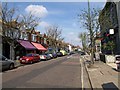
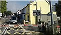
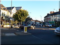
White Hart Lane, Mortlake
Some colourful shop canopies opposite the junction with Image, with gables above the facades.
Image: © Derek Harper
Taken: 15 Apr 2010
0.04 miles
2
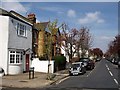
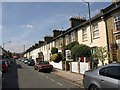
First Avenue, Mortlake
The first of a series of streets parallel to and west of Image After this and Second Avenue, the names become more imaginative. Viewed from North Worple Way, which runs across the southern end of each of the streets.
Image: © Derek Harper
Taken: 15 Apr 2010
0.05 miles
3
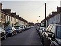
Thorne Street, Barnes
Looking west towards White Hart Lane. Little terraced cottages - but with an enormous number of chimney pots. A local resident told me the street dates from 1886.
Image: © Stefan Czapski
Taken: 17 May 2014
0.07 miles
4
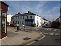
White Hart Lane and Westfields Avenue
A road junction in Mortlake; White Hart Lane is the main road. Westfields Avenue, which runs parallel to Image, recalls one of the neighbourhood's names: Westfield was a rich market garden on this site. The pleasant, modest terraces now give rise to the name "Little Chelsea".
Image: © Derek Harper
Taken: 15 Apr 2010
0.07 miles
5
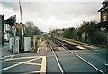
White Hart Lane, Mortlake, from the train
Level crossings are relatively unusual in London, but the line from Clapham Junction to Richmond is characterised by a run of several. Plans to use this line for a fast link to Heathrow foundered repeatedly on this fact: increased use of the line would mean these gates were closed every few minutes, immobilising traffic, whilst replacing them with bridges in this low-lying terrain would mean many residents' view out of the front door would be of the side of a ramp carrying the road over the railway.
Image: © Christopher Hilton
Taken: 8 Aug 2013
0.09 miles
6
Archway Street, Mortlake
A resident who wondered what I was doing said he chose to live in this road because of its architectural appearance; an architect explained that the combined height of the houses on either side equalled the total distance between them.
Image: © Derek Harper
Taken: 15 Apr 2010
0.09 miles
7
Level crossing on White Hart Lane, Mortlake
Image: © David Howard
Taken: Unknown
0.10 miles
8
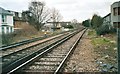
Railway lines from White Hart Lane, Mortlake
Image: © David Howard
Taken: Unknown
0.10 miles
10
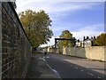
South Worple Way in October
The railway line from Barnes to Mortlake runs behind the wall on the right. The wall on the left marks the northern boundary of the Barnes Hospital site.
Image: © Stefan Czapski
Taken: 25 Oct 2020
0.11 miles