IMAGES TAKEN NEAR TO
Vernon Road, LONDON, SW14 8NU
Introduction
This page details the photographs taken nearby to Vernon Road, SW14 8NU by members of the Geograph project.
The Geograph project started in 2005 with the aim of publishing, organising and preserving representative images for every square kilometre of Great Britain, Ireland and the Isle of Man.

There are currently over 7.5m images from over14,400 individuals and you can help contribute to the project by visiting https://www.geograph.org.uk
Image Map
Images are licensed for reuse under creativecommons.org/licenses/by-sa/2.0
Notes
- Clicking on the map will re-center to the selected point.
- The higher the marker number, the further away the image location is from the centre of the postcode.
Image Listing (223 Images Found)
Images are licensed for reuse under creativecommons.org/licenses/by-sa/2.0
Image
Details
Distance
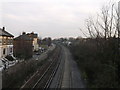
1
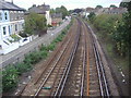
Railway line in Mortlake
Between North and South Worple Way
Image: © David Howard
Taken: 7 Sep 2009
0.09 miles

3
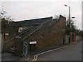
Footbridge near South Worple Way, Mortlake
This bridge leads to North Worple Way.
It passes over the railway between Barnes and Mortlake.
Image: © David Anstiss
Taken: 13 Jan 2013
0.09 miles
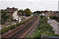
4
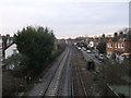
Railway to Barnes
As seen from Image
South Morple Way is on the left.
Image: © David Anstiss
Taken: 13 Jan 2013
0.09 miles
5
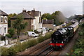
No.46100 'Royal Scot'
Seen approaching Mortlake with a circular railtour from Victoria via Woking, Guildford and Redhill.
Image: © Peter Trimming
Taken: 23 Sep 2017
0.09 miles
6
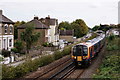
Mortlake
Class 450 unit seen approaching the station.
Image: © Peter Trimming
Taken: 23 Sep 2017
0.09 miles
7
Railway to Mortlake
As seen from Image
South Morple Way is on the left.
In the background the footbridge at Mortlake Station can be seen.
Image: © David Anstiss
Taken: 13 Jan 2013
0.09 miles
8
Mortlake
The railway lines to the east of the station.
Image: © Peter Trimming
Taken: 23 Sep 2017
0.09 miles
9
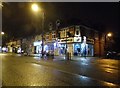
Shops on Upper Richmond Road, East Sheen
Image: © David Howard
Taken: 14 Oct 2014
0.09 miles
10
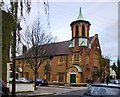
Sheen Vale Congregational Church - now Thompson House School
At the corner of Vernon Road and Howgate Road. A foundation stone is dated 1901: http://www.geograph.org.uk/photo/4240392
I notice that in older OS mappings the church is represented by a simple cross. The octagonal tower (vaguely Greek-looking) with its curious roof - shaped like the trumpet on an early gramophone - apparently didn't qualify it for either the 'church with tower' or 'church with spire' symbols that were the convention until recently.
Image: © Stefan Czapski
Taken: 7 Nov 2014
0.11 miles