IMAGES TAKEN NEAR TO
Mortlake High Street, LONDON, SW14 8HL
Introduction
This page details the photographs taken nearby to Mortlake High Street, SW14 8HL by members of the Geograph project.
The Geograph project started in 2005 with the aim of publishing, organising and preserving representative images for every square kilometre of Great Britain, Ireland and the Isle of Man.

There are currently over 7.5m images from over14,400 individuals and you can help contribute to the project by visiting https://www.geograph.org.uk
Image Map (Loading...)


Getting Data...Please wait
Leaflet Map data © OpenStreetMap
Images are licensed for reuse under creativecommons.org/licenses/by-sa/2.0
Notes
- Clicking on the map will re-center to the selected point.
- The higher the marker number, the further away the image location is from the centre of the postcode.
Image Listing (299 Images Found)
Images are licensed for reuse under creativecommons.org/licenses/by-sa/2.0
Image
Details
Distance
2
View from the Thames Path National Trail near Mortlake
Image: © Dave Kelly
Taken: 17 May 2018
0.02 miles
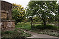
3
Flood defence, Mortlake
Debris from the Thames by a defence gate in Mortlake.
Image: © Eirian Evans
Taken: 20 Oct 2010
0.03 miles
4
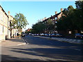
Mortlake High Street
Looking east, with the brewery, on its riverside site, on the left. As High Streets go, this has got to be one of the dreariest, with very few shops and just one pub. Nearby you can find Tinderbox Alley, Vineyard Path and Tapestry Court, whose names suggest a more interesting past. But on the ground, there are few traces of it: the parish church, a few Georgian houses, some converted industrial buildings along the riverside. The brewers Phillips and Wigan had demolished much of the old riverside village by the time the brewery was built, in 1869.
These days the local shopping centre - 'Sheen shops' - starts round the corner in Sheen Lane, but extends on a larger scale along Upper Richmond Road West. The railway station which serves it is still known as 'Mortlake' - a fact which surprises people unfamiliar with the area.
It has to be said that this is a district where place names have a tendency to wander. Richmond was known as Sheen up until about 1500, when Henry VII built a new palace there. A hamlet about a mile south of Mortlake became known as East Sheen, but the name later attached itself to the suburb which grew up along the Upper Richmond Road. These days the 'East' is frequently forgotten, and the place is known simply as Sheen.
Image: © Stefan Czapski
Taken: 22 Jul 2011
0.03 miles
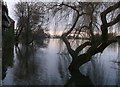
5
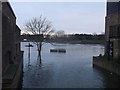
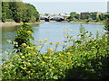
Flooded Thames, Bull's Alley
Normally a small path runs beside the river, in front of the houses (on the right) towards Barnes Bridge. It also should lead right to Chiswick Bridge (in front of a Brewery).
The benches and tree is close to where the river edge should be.
Image: © David Anstiss
Taken: 13 Jan 2013
0.03 miles
6
Thames Path
Seen from the slipway, immediately outside the former Stag Brewery.
Image: © Peter Trimming
Taken: 23 Sep 2017
0.03 miles
7
Slipway At Mortlake
Located beside the former Stag Brewery. The Thames Path runs across the foreground.
Image: © Peter Trimming
Taken: 23 Sep 2017
0.03 miles
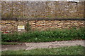
8
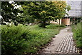
Thames Path
Located beside the former Stag Brewery, at Mortlake. Rail tracks can be seen crossing the path, at this point, but the wall, which lies just out of picture to the right, shows no recent access from within the brewery site.
Image]
Image: © Peter Trimming
Taken: 23 Sep 2017
0.05 miles
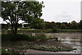
9
Flooded Thames Path, Mortlake
As seen from the Thames Path near Tapestry Court.
Looking up-stream towards Chiswick Bridge.
Normally a small path runs in front of these houses, beside the river towards the bridge.
Image: © David Anstiss
Taken: 13 Jan 2013
0.05 miles
10
Thames Path
Located beside the former Stag Brewery, at Mortlake. Rail tracks can be seen crossing the path, at this point, but the wall shows no recent access from within the brewery site.
Image: © Peter Trimming
Taken: 23 Sep 2017
0.05 miles