IMAGES TAKEN NEAR TO
Balham Hill, LONDON, SW12 9DX
Introduction
This page details the photographs taken nearby to Balham Hill, SW12 9DX by members of the Geograph project.
The Geograph project started in 2005 with the aim of publishing, organising and preserving representative images for every square kilometre of Great Britain, Ireland and the Isle of Man.

There are currently over 7.5m images from over14,400 individuals and you can help contribute to the project by visiting https://www.geograph.org.uk
Image Map
Images are licensed for reuse under creativecommons.org/licenses/by-sa/2.0
Notes
- Clicking on the map will re-center to the selected point.
- The higher the marker number, the further away the image location is from the centre of the postcode.
Image Listing (211 Images Found)
Images are licensed for reuse under creativecommons.org/licenses/by-sa/2.0
Image
Details
Distance
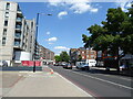
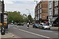
1
Balham Hill shops
A few shops on the A24, at its junction with Hazelbourne Road (left). .
Image: © Stephen Craven
Taken: 18 Jun 2014
0.01 miles
2
Balham Hill
The A24 through Balham, at its junction with Gaskarth Road (left). Note the blue "cycle superhighway".
Image: © Stephen Craven
Taken: 18 Jun 2014
0.02 miles
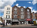
3
Gaskarth Road, Clapham
The office block in the acute angled building (Marsh & Parsons) has attractive plaster panels on its facade, and plaster flowers on the corners
Image: © David Smith
Taken: 17 Nov 2016
0.02 miles
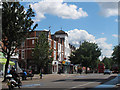
5

Buildings close to Clapham South Station
Image: © Andrew Wilson
Taken: 27 Apr 2013
0.02 miles
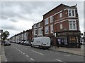
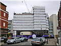
6
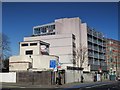
Clapham South deep shelter (south), Balham Hill, SW12 (3)
In late 1940, the government decided to build a system of deep (air raid) shelters linked to existing underground stations. Each deep shelter consisted of two parallel tubes that might be used for future express underground lines. Seven such shelters were built at Northern Line stations - Belsize Park, Camden Town, Goodge Street, Stockwell, Clapham North, Clapham Common and Clapham South. Each shelter had two entrances with a “pill box” and ventilation shafts; most of these are still there today (February 2011). Some of the deep shelters are in use for secure storage of documents.
This shelter can be seen on the satellite image http://wtp2.appspot.com/wheresthepath.htm?lat=51.45175046583516&lon=-0.14803379774093628&gz=19&oz=10>=1 . [Source: “Beneath the City Streets” by Peter Laurie (1970, revised 1979).]
Image: © Mike Quinn
Taken: 8 Feb 2011
0.03 miles
7
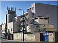
Clapham South deep shelter (south), Balham Hill, SW12
In late 1940, the government decided to build a system of deep (air raid) shelters linked to existing underground stations. Each deep shelter consisted of two parallel tubes that might be used for future express underground lines. Seven such shelters were built at Northern Line stations - Belsize Park, Camden Town, Goodge Street, Stockwell, Clapham North, Clapham Common and Clapham South. Each shelter had two entrances with a “pill box” and ventilation shafts; most of these are still there today (February 2011). Some of the deep shelters are in use for secure storage of documents.
From the remains of the sign, now saying only "all", above and to the left of the blue gates, and the estate agent's "sold" notice, it would appear that this shelter was until recently used by Recall http://www.recalldms.co.uk/index.html a Brambles Company http://www.brambles.com/BXB/content/home.html, as is currently (February 2011) the Image
This shelter can be seen on the satellite image http://wtp2.appspot.com/wheresthepath.htm?lat=51.45175046583516&lon=-0.14803379774093628&gz=19&oz=10>=1 . [Source: “Beneath the City Streets” by Peter Laurie (1970, revised 1979).]
Betond the shelter (left) is the Image photographed by Danny Robinson; the shelter is just visible on the right hand side of his photo.
Image: © Mike Quinn
Taken: 8 Feb 2011
0.03 miles
8
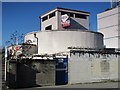
Clapham South deep shelter (south), Balham Hill, SW12 (2)
In late 1940, the government decided to build a system of deep (air raid) shelters linked to existing underground stations. Each deep shelter consisted of two parallel tubes that might be used for future express underground lines. Seven such shelters were built at Northern Line stations - Belsize Park, Camden Town, Goodge Street, Stockwell, Clapham North, Clapham Common and Clapham South. Each shelter had two entrances with a “pill box” and ventilation shafts; most of these are still there today (February 2011). Some of the deep shelters are in use for secure storage of documents.
This shelter can be seen on the satellite image http://wtp2.appspot.com/wheresthepath.htm?lat=51.45175046583516&lon=-0.14803379774093628&gz=19&oz=10>=1 . [Source: “Beneath the City Streets” by Peter Laurie (1970, revised 1979).]
Image: © Mike Quinn
Taken: 8 Feb 2011
0.03 miles
9
Building flats, Balham Hill
The extraordinary thing is that the flats are being built over and around the cylindrical structure, which is the southern entrance to Clapham South deep air raid shelter. The northern entrance may be seen on Clapham Common.
Image: © Robin Webster
Taken: 6 May 2012
0.03 miles