Clapham South deep shelter (south), Balham Hill, SW12
Introduction
The photograph on this page of Clapham South deep shelter (south), Balham Hill, SW12 by Mike Quinn as part of the Geograph project.
The Geograph project started in 2005 with the aim of publishing, organising and preserving representative images for every square kilometre of Great Britain, Ireland and the Isle of Man.

There are currently over 7.5m images from over 14,400 individuals and you can help contribute to the project by visiting https://www.geograph.org.uk
Clapham South deep shelter (south), Balham Hill, SW12
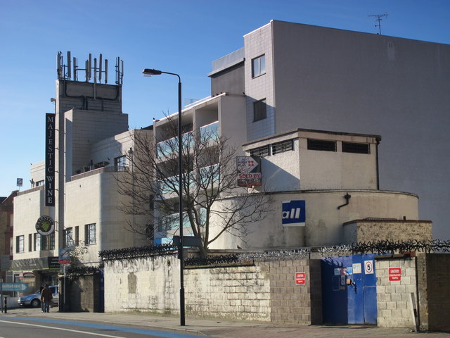
Image: © Mike Quinn Taken: 8 Feb 2011
In late 1940, the government decided to build a system of deep (air raid) shelters linked to existing underground stations. Each deep shelter consisted of two parallel tubes that might be used for future express underground lines. Seven such shelters were built at Northern Line stations - Belsize Park, Camden Town, Goodge Street, Stockwell, Clapham North, Clapham Common and Clapham South. Each shelter had two entrances with a “pill box” and ventilation shafts; most of these are still there today (February 2011). Some of the deep shelters are in use for secure storage of documents. From the remains of the sign, now saying only "all", above and to the left of the blue gates, and the estate agent's "sold" notice, it would appear that this shelter was until recently used by Recall http://www.recalldms.co.uk/index.html a Brambles Company http://www.brambles.com/BXB/content/home.html, as is currently (February 2011) the Image This shelter can be seen on the satellite image http://wtp2.appspot.com/wheresthepath.htm?lat=51.45175046583516&lon=-0.14803379774093628&gz=19&oz=10>=1 . [Source: “Beneath the City Streets” by Peter Laurie (1970, revised 1979).] Betond the shelter (left) is the Image photographed by Danny Robinson; the shelter is just visible on the right hand side of his photo.
Images are licensed for reuse under creativecommons.org/licenses/by-sa/2.0
Image Location
Latitude
51.451705
Longitude
-0.148009