IMAGES TAKEN NEAR TO
Alderbrook Road, LONDON, SW12 8AG
Introduction
This page details the photographs taken nearby to Alderbrook Road, SW12 8AG by members of the Geograph project.
The Geograph project started in 2005 with the aim of publishing, organising and preserving representative images for every square kilometre of Great Britain, Ireland and the Isle of Man.

There are currently over 7.5m images from over14,400 individuals and you can help contribute to the project by visiting https://www.geograph.org.uk
Image Map
Images are licensed for reuse under creativecommons.org/licenses/by-sa/2.0
Notes
- Clicking on the map will re-center to the selected point.
- The higher the marker number, the further away the image location is from the centre of the postcode.
Image Listing (200 Images Found)
Images are licensed for reuse under creativecommons.org/licenses/by-sa/2.0
Image
Details
Distance
1
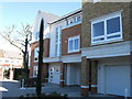
Joule House, Nightingale Mews SW12 8DB
New house for sale at £2.5 million
Image: © Alex McGregor
Taken: 8 Mar 2010
0.05 miles
2
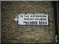
Pre-Worboys sign to church, Alderbrook Road Balham
Image: © David Howard
Taken: 28 Feb 2010
0.06 miles
3
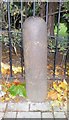
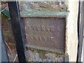
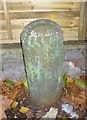
Old Boundary Marker by Alderbrook Road, Battersea parish
Parish Boundary Marker by the UC road, in parish of Battersea (Wandsworth District), Alderbrook Road SW12, North end at junction with the B237 Nightingale Lane, against railings. Opposite: SY_BATT16pb Image
Inscription reads:-
BATTERSEA
Grade II listed:-
List Entry Number: 1065577 https://historicengland.org.uk/listing/the-list/list-entry/1065577
Surveyed
Milestone Society National ID: SY_BATT15pb
Image: © Milestone Society
Taken: Unknown
0.06 miles
4

Old Boundary Marker by Alderbrook Road, Battersea parish
Parish Boundary Marker by the UC road, in parish of Battersea (Wandsworth District), Alderbrook Road SW12 North end, at junction with the B237 Nightingale Lane, against wall. Opposite: SY_BATT15pb Image
Inscription reads:-
BATTERSEA
Grade II listed:-
List Entry Number: 1065577 https://historicengland.org.uk/listing/the-list/list-entry/1065577
Surveyed
Milestone Society National ID: SY_BATT16pb
Image: © Milestone Society
Taken: Unknown
0.06 miles
5
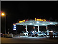
Sainsbury filling station, Nightingale Lane
An interesting bit of research http://list.english-heritage.org.uk/resultsingle.aspx?uid=1357669 showed that as of 1983, this was an Elf petrol station but is now part of a supermarket chain.
Petrol was retailing at 125.9p per litre.
Image: © Stephen Craven
Taken: 26 Apr 2014
0.07 miles
6
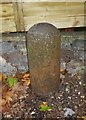
Old Boundary Marker by the B229, Nightingale Lane SW12
Parish Boundary Marker by the B229, in parish of Battersea (Wandsworth District), Nightingale Lane SW12, on end of wall between Clavering Place and service station, 50cm above ground, left-hand side.
Boundary Wall Grade II listed.
List Entry Number: 1357669 https://historicengland.org.uk/listing/the-list/list-entry/1357669
Surveyed
Milestone Society National ID: SY_BATT01pb.
Image: © Milestone Society
Taken: Unknown
0.07 miles
7
Old Boundary Marker by the B229, Nightingale Lane, Battersea
Parish Boundary Marker by the B229, in parish of Battersea (Wandsworth District), Nightingale Lane SW12, on end of wall between Clavering Place and service station, 50cm above ground, right-hand side.
Grade II Listed. List Entry Number: 1357669
https://historicengland.org.uk/listing/the-list/list-entry/1357669
Surveyed
Milestone Society National ID: SY_BATT02pb.
Image: © Milestone Society
Taken: Unknown
0.07 miles
8
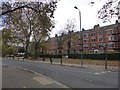
Clapham Mansions overlooking Clapham Common
Using the word "Mansions" to describe apartments seems to devalue the word.
Image: © David Smith
Taken: 17 Nov 2016
0.07 miles
9
Old Boundary Marker by the B229, Clapham Mansions, Nightingale Lane
Parish Boundary Marker by the B229, in parish of Battersea (Wandsworth District), Nightingale Lane SW12, Clapham Mansions, West end against boundary wall, South side of road.
Grade II listed as one of a group of 13.
List Entry Number: 1065560 https://historicengland.org.uk/listing/the-list/list-entry/1065560
Surveyed
Milestone Society National ID: SY_BATT10pb
Image: © Milestone Society
Taken: Unknown
0.07 miles
10
Old Boundary Marker by the B237, Nightingale Lane, Clapham
Estate Boundary Marker by the B237, in parish of Battersea (Wandsworth District), Nightingale Lane SW12, Clapham Mansions, South end of boundary wall.
Inscription reads:-
LONDON
COUNTY
COUNCIL
BOUNDARY
13 Boundary Markers are Grade II listed.
List Entry Number: 1065560 https://historicengland.org.uk/listing/the-list/list-entry/1065560
Surveyed
Milestone Society National ID: SY_LCC20em
Image: © Milestone Society
Taken: Unknown
0.07 miles