IMAGES TAKEN NEAR TO
New Mill Road, LONDON, SW11 7AS
Introduction
This page details the photographs taken nearby to New Mill Road, SW11 7AS by members of the Geograph project.
The Geograph project started in 2005 with the aim of publishing, organising and preserving representative images for every square kilometre of Great Britain, Ireland and the Isle of Man.

There are currently over 7.5m images from over14,400 individuals and you can help contribute to the project by visiting https://www.geograph.org.uk
Image Map
Images are licensed for reuse under creativecommons.org/licenses/by-sa/2.0
Notes
- Clicking on the map will re-center to the selected point.
- The higher the marker number, the further away the image location is from the centre of the postcode.
Image Listing (231 Images Found)
Images are licensed for reuse under creativecommons.org/licenses/by-sa/2.0
Image
Details
Distance
1
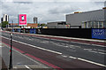
Vacant site, Nine Elms Lane
The area bounded by the road to the north and the railway to the south is currently occupied by warehouses and depots dating from the 1970s, but at least one has been cleared in preparation for the new US Embassy (hence the area being christened "Embassy Quarter"). Building work is due to start in 2013 and finish in 2017.
The towers either side of the red hoarding are Market Towers (Image]) and Keybridge House (Image]).
Image: © Stephen Richards
Taken: Unknown
0.04 miles
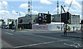
3
All that remains of London South Mail Centre
Now a valuable new development site.
Image: © Bill Boaden
Taken: 11 Oct 2015
0.05 miles
4
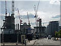
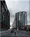
Development, Nine Elms Lane (1)
Vauxhall's skyline currently resembles a world convention of cranes and is likely to continue to do so for some time. Cut through the marketing guff about creating new neighbourhoods (very few "ordinary" Londoners will be able to afford to live here) and the blather about transformation, and one is still left with an epic scale of development, spurred on by two things: a scheme for Battersea Power Station which actually appears to be viable, and the re-location of the new US Embassy (to somewhere towards the left of this photo).
Seen here is a small slice of the total of twenty-plus different scheme across 195 hectares, the ouput of which will be 18,000 flats, a new pedestrian bridge across the Thames, extensions to the Northern Line, and, inescapably, "riverside shops, cafes, restaurants, art galleries, parks and public squares". On the left is Embassy Gardens (developers Ballymore Group). Further away on the right is Riverlight (developers St James Group Ltd).
Image: © Stephen Richards
Taken: 4 May 2014
0.05 miles
5

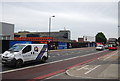
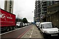
London : Battersea - Nine Elms Road
Looking along Nine Elms Road with some advertising hoardings on the opposite side.
Image: © Lewis Clarke
Taken: 13 May 2011
0.06 miles
6
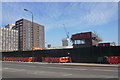
Nine Elms Lane (1)
The cranes are now less prominent than in Image], sixteen months earlier. The exteriors of these flats look pretty much done, but work remains on the interiors. Despite that, at the time of writing, all but one of the Riverlight flats (right) so far offered for sale has been snapped up. The developers' website had one ground-floor one-bedroom flat available for £800k.
Battersea Power Station chimneys are visible on the far right.
Image: © Stephen Richards
Taken: 12 Sep 2015
0.06 miles
8
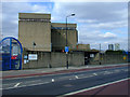
Thames Water facility
On Nine Elms Road.
Image: © Thomas Nugent
Taken: 21 Mar 2011
0.07 miles
9
Embassy Gardens, Nine Elms Road
A large scale housing development at the junction with Ponton Road.
Image: © Thomas Nugent
Taken: 19 May 2014
0.07 miles
10
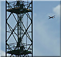
Aircraft over Battersea
The aircraft has approached from the east and is probably banking into the turn for London City Airport. The crane is at the Embassy Gardens building site on Nine Elms Road Image
Image: © Thomas Nugent
Taken: 19 May 2014
0.07 miles