IMAGES TAKEN NEAR TO
Waterfront Drive, LONDON, SW10 0JR
Introduction
This page details the photographs taken nearby to Waterfront Drive, SW10 0JR by members of the Geograph project.
The Geograph project started in 2005 with the aim of publishing, organising and preserving representative images for every square kilometre of Great Britain, Ireland and the Isle of Man.

There are currently over 7.5m images from over14,400 individuals and you can help contribute to the project by visiting https://www.geograph.org.uk
Image Map (Loading...)


Getting Data...Please wait
Leaflet Map data © OpenStreetMap
Images are licensed for reuse under creativecommons.org/licenses/by-sa/2.0
Notes
- Clicking on the map will re-center to the selected point.
- The higher the marker number, the further away the image location is from the centre of the postcode.
Image Listing (286 Images Found)
Images are licensed for reuse under creativecommons.org/licenses/by-sa/2.0
Image
Details
Distance
1
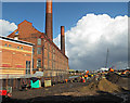
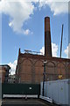
Former Chelsea Power Station
Viewed from Chelsea Harbour Drive.
Image: © Thomas Nugent
Taken: 8 Oct 2014
0.02 miles
2
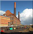
Former Chelsea Power Station
Viewed from Chelsea Harbour Drive.
Image: © Thomas Nugent
Taken: 8 Oct 2014
0.02 miles
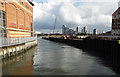
3
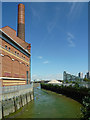
Chelsea Creek
Looking down Chelsea Creek at low tide, with the former Lots Road Power Station on the left and the Montevetro development in Battersea Church Road in the distance on the right. In the centre, behind the heap of rubble, can be seen the chimneys of the Battersea Power Station.
Image: © Ian Capper
Taken: 6 May 2010
0.02 miles
4
Chelsea Creek
Looking down Chelsea Creek at low tide, with the former Lots Road Power Station on the left and the Montevetro development in Battersea Church Road in the distance on the right. In the centre, behind the heap of rubble, can be seen the chimneys of the Battersea Power Station.
Image: © Ian Capper
Taken: 6 May 2010
0.03 miles
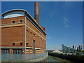
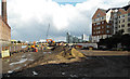
6
Chelsea Creek
The final few hundred metres leading to the Thames. Viewed from the bridge over Chelsea Creek at Chelsea Harbour Drive. Part of the former Chelsea Power Station can be seen on the left.
Image: © Thomas Nugent
Taken: 8 Oct 2014
0.03 miles
7
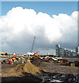
Riverside development site
Between Chelsea Creek and Chelsea Harbour.
Image: © Thomas Nugent
Taken: 8 Oct 2014
0.03 miles
8
Riverside development site
Between Chelsea Creek and Chelsea Harbour. The disused Chelsea Power Station is on the left.
Image: © Thomas Nugent
Taken: 8 Oct 2014
0.03 miles
10
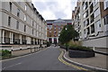
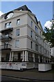
London : Chelsea - Chelsea Harbour Drive
Chelsea Harbour Drive is surrounded by apartments and is close to the harbour and river.
Image: © Lewis Clarke
Taken: 13 May 2011
0.03 miles