IMAGES TAKEN NEAR TO
Springhead Close, STOKE-ON-TRENT, ST7 1QA
Introduction
This page details the photographs taken nearby to Springhead Close, ST7 1QA by members of the Geograph project.
The Geograph project started in 2005 with the aim of publishing, organising and preserving representative images for every square kilometre of Great Britain, Ireland and the Isle of Man.

There are currently over 7.5m images from over14,400 individuals and you can help contribute to the project by visiting https://www.geograph.org.uk
Image Map
Images are licensed for reuse under creativecommons.org/licenses/by-sa/2.0
Notes
- Clicking on the map will re-center to the selected point.
- The higher the marker number, the further away the image location is from the centre of the postcode.
Image Listing (20 Images Found)
Images are licensed for reuse under creativecommons.org/licenses/by-sa/2.0
Image
Details
Distance
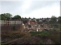
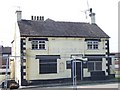
1
Talke Pits: The Skylark
Back of The Skylark, finally facing demolition after having been closed and boarded up for two years. The pub was at one time run by darts ace Andy "The Hammer" Hamilton.
Image: © Jonathan Hutchins
Taken: 15 May 2015
0.06 miles
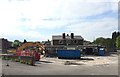
2
Talke Pits: The Skylark demolished
Compare with Image
Image: © Jonathan Hutchins
Taken: 30 May 2015
0.06 miles
3
Talke Pits: The Skylark
After being closed and boarded up for two years The Skylark is finally facing demolition. The pub was at one time run by darts ace Andy "The Hammer" Hamilton.
Image: © Jonathan Hutchins
Taken: 15 May 2015
0.07 miles
5
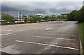
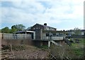
Freeport Talke: car park
Empty at 8:30 on a Saturday morning, since it opens at 10 a.m.
Image: © Jonathan Hutchins
Taken: 30 May 2015
0.08 miles
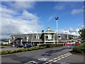
7
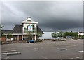
Freeport Talke: north-east entrance
Image: © Jonathan Hutchins
Taken: 30 May 2015
0.10 miles
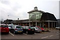
8
Freeport, Talke
Another view of the mall shown in http://www.geograph.org.uk/search.php?i=15920733 . I got stuck here for over half an hour: I drove into what appeared to be the car park, only to discover it was the staff car park, which has the highly sensible arrangement of allowing you to drive in, but preventing you from getting out without some sort of staff code, thus necessitating the calling out of an irate premises officer, who informed me that "the same *** thing happened yesterday". Did he put two and two together and make a case for a different way of organising things? I confess I've not been back to find out. Meanwhile, my sole purpose for the visit was to find an Ordnance Survey map of the area, but the mall didn't even have anything resembling a bookshop, so it was a complete waste of time.
Image: © Derek Harper
Taken: 30 Jun 2006
0.10 miles
9
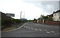
Talke Pits: Pit Lane
Leads past the Jamage Industrial Estate on the left. The pavement on the right is also the route of a public footpath, designated Kidsgrove 203.
Image: © Jonathan Hutchins
Taken: 30 May 2015
0.11 miles
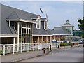
10
Freeport Talke: south-east entrance
Image: © Jonathan Hutchins
Taken: 30 May 2015
0.13 miles