IMAGES TAKEN NEAR TO
Whitehall Avenue, STOKE-ON-TRENT, ST7 1ES
Introduction
This page details the photographs taken nearby to Whitehall Avenue, ST7 1ES by members of the Geograph project.
The Geograph project started in 2005 with the aim of publishing, organising and preserving representative images for every square kilometre of Great Britain, Ireland and the Isle of Man.

There are currently over 7.5m images from over14,400 individuals and you can help contribute to the project by visiting https://www.geograph.org.uk
Image Map
Images are licensed for reuse under creativecommons.org/licenses/by-sa/2.0
Notes
- Clicking on the map will re-center to the selected point.
- The higher the marker number, the further away the image location is from the centre of the postcode.
Image Listing (144 Images Found)
Images are licensed for reuse under creativecommons.org/licenses/by-sa/2.0
Image
Details
Distance
1

Shopping parade, Kidsgrove
This is on King Street. At 8:39 am by no means everything is open - but perhaps some shops are closed permanently.
Image: © Derek Harper
Taken: 30 Jun 2006
0.08 miles
2
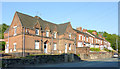
Housing in Kidsgrove, Staffordshire
These are in Liverpool Road, the A50 approaching Kidsgrove town centre. The fine building (now three separate dwellings) nearest the camera is shown on old maps as a police station.
Gordon Hassall reports that the station was probably closed in 1975 or 1976. http://www.bbc.co.uk/history/domesday/dblock/GB-384000-354000/page/19
Image: © Roger D Kidd
Taken: 1 Sep 2011
0.09 miles
3
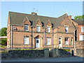
Impressive house in Kidsgrove, Staffordshire
50, 52 and 54 Liverpool Road.
Currently this is divided into three dwellings. Early maps show that it used to be a police station. Gordon Hassall reports that the station was probably closed in 1975 or 1976. http://www.bbc.co.uk/history/domesday/dblock/GB-384000-354000/page/19
Image: © Roger D Kidd
Taken: 1 Sep 2011
0.10 miles
4
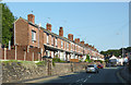
Terraced housing in Kidsgrove, Staffordshire
This is looking south-east up Liverpool Road (A50) towards Kidsgrove town centre.
Image: © Roger D Kidd
Taken: 1 Sep 2011
0.10 miles
8

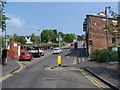
Liverpool Road, Kidsgrove
A number of "to let" signs along one of Kidsgrove's main shopping streets, the A50, seen from the junction with Heathcote Street.
Image: © Derek Harper
Taken: 30 Jun 2006
0.11 miles
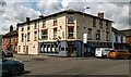
9
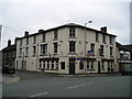
The Harecastle Hotel Pub, Kidsgrove, Stoke on Trent
Liverpool Road, Kidsgrove Stoke on Trent ST7 1EA near to The Trent and Mersey Canal
Image: © canalandriversidepubs co uk
Taken: 11 Jun 2010
0.11 miles
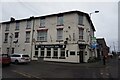
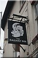
10
The Railway Inn
The Railway Inn at Kidsgrove.
Image: © Peter McDermott
Taken: 13 Jul 2023
0.11 miles