IMAGES TAKEN NEAR TO
Cemetery Road, NEWCASTLE, ST5 6PJ
Introduction
This page details the photographs taken nearby to Cemetery Road, ST5 6PJ by members of the Geograph project.
The Geograph project started in 2005 with the aim of publishing, organising and preserving representative images for every square kilometre of Great Britain, Ireland and the Isle of Man.

There are currently over 7.5m images from over14,400 individuals and you can help contribute to the project by visiting https://www.geograph.org.uk
Image Map
Images are licensed for reuse under creativecommons.org/licenses/by-sa/2.0
Notes
- Clicking on the map will re-center to the selected point.
- The higher the marker number, the further away the image location is from the centre of the postcode.
Image Listing (18 Images Found)
Images are licensed for reuse under creativecommons.org/licenses/by-sa/2.0
Image
Details
Distance
1
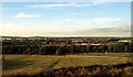
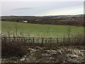
Looking towards Silverdale, Staffordshire
Image: © Claire MacNeill
Taken: 20 Aug 2012
0.06 miles
2
Frog Sculpture, Gallowstree Island
8ft metal sculpture of a frog leaping onto a lily pad near Keele University.
The sculpture created by sculptor and North Staffordshire born Andy Edwards who is famous for The Beatles at the Waterfront statue in Liverpool was installed March 2021
https://www.stokesentinel.co.uk/news/stoke-on-trent-news/new-roadside-sculpture-leaps-onto-5214860
Image: © Brian Deegan
Taken: 23 Mar 2021
0.12 miles
3
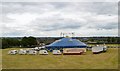
Newcastle-under-Lyme: circus in Hamptons Field
Chipperfield's Circus was here from 9th-12th July 2015, giving two shows a day (three on Saturday). This is Newcastle's traditional circus field: other shows which visit or have visited to perform here in recent years include Circus Funtasia and Bobby Roberts' Super Circus.
Image: © Jonathan Hutchins
Taken: 11 Jul 2015
0.13 miles
4
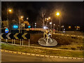
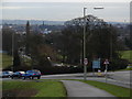
Gallowstree Roundabout
Nine years to the day after Image It is not possible to reproduce the vantage point of the earlier photograph without standing in the middle of a busy road!
The roundabout was completely remodelled and rebuilt in 2009 at a cost of around £3m, being widened and creating additional traffic lanes. This caused considerable local controversy, since the opportunity for increased speed and density of traffic was viewed with alarm by pedestrians and cyclists, while the roadworks themselves caused severe traffic queues, backing up into Newcastle itself, and (allegedly) adversely affected some local businesses. Trees and bushes were destroyed leaving just the one tree in the centre of the roundabout.
The purpose of the rebuilding was to improve access and traffic flow in the light of potentially extensive future development of Phase 3 of Keele University's Science and Business Park (currently still a delightful wildflower meadow!) Image
Image: © Jonathan Hutchins
Taken: 14 Jan 2015
0.13 miles
5
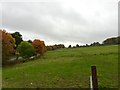
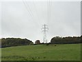
Field between Keele Road and Cemetery Road
This is the same field as seen in http://www.geograph.org.uk/photo/4312931 and http://www.geograph.org.uk/photo/4312941. Cars heading towards Silverdale can be seen travelling west along Cemetery Road just in front of the line of trees towards the top of the picture.
Image: © Jonathan Hutchins
Taken: 14 Jan 2015
0.13 miles
6
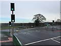
Roundabout on the A525
Not very many interesting things in this square, in my opinion! I figured this view down the A525 towards Newcastle-under-Lyme and Stoke is worth showing, though.
Image: © Iain McDonald
Taken: 14 Jan 2006
0.14 miles
7
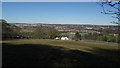
Silverdale: field south of village
View looking towards Gallowstree Roundabout on the Keele Road.
Image: © Jonathan Hutchins
Taken: 24 Oct 2015
0.16 miles
8
Newcastle under Lyme - View NE towards Keele Rd Roundabout from The Cloughs trig point
Image: © Colin Park
Taken: 7 Mar 2016
0.17 miles
10
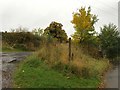
Silverdale: footpath off Park Road
Footpath designated Silverdale FP 22 leads off Park Road immediately after the latter's junction with Cemetery Road.
Image: © Jonathan Hutchins
Taken: 24 Oct 2015
0.20 miles