IMAGES TAKEN NEAR TO
Three Mile Lane, NEWCASTLE, ST5 5HQ
Introduction
This page details the photographs taken nearby to Three Mile Lane, ST5 5HQ by members of the Geograph project.
The Geograph project started in 2005 with the aim of publishing, organising and preserving representative images for every square kilometre of Great Britain, Ireland and the Isle of Man.

There are currently over 7.5m images from over14,400 individuals and you can help contribute to the project by visiting https://www.geograph.org.uk
Image Map
Images are licensed for reuse under creativecommons.org/licenses/by-sa/2.0
Notes
- Clicking on the map will re-center to the selected point.
- The higher the marker number, the further away the image location is from the centre of the postcode.
Image Listing (8 Images Found)
Images are licensed for reuse under creativecommons.org/licenses/by-sa/2.0
Image
Details
Distance
1
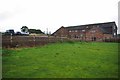
Path at Lower Stoneylow Farm
The path passes over the fence and across the newly seeded lawn. I bet the residents don't get piles of hand delivered fliers for the local burger bars and curry houses!
Image: © Glyn Baker
Taken: 2 Sep 2012
0.03 miles
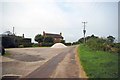
2

Lower Stoneylow Farm
Taken from the footpath that approaches the farm buildings, this shows one of the typical pastures that are present for miles around, along with a rather gnarled old oak tree.
Image: © Iain McDonald
Taken: 2 Oct 2005
0.06 miles
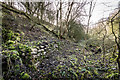
3
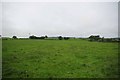
Pasture near Lower Stoneylow Farm
The footpath to Madeley passes under the power cables in the distance.
Image: © Glyn Baker
Taken: 2 Sep 2012
0.07 miles
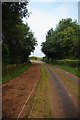
4
Footpath at Stoney Low Farm
Almost at the end of the surfaced path to Madeley.
Image: © Glyn Baker
Taken: 2 Sep 2012
0.10 miles
5
Old Railway Bridge Near Stoney Low
I can't understand why the O.S maps don't show the railway as disused or dismantled. A look over the hedge into the deep cutting reveals large trees where the track should be. They have clearly not sprung up in a couple of years. Sadly the vegetation was far too dense to get a decent picture.
2013 Update... it seems The track is the remnant of the line between Market Drayton and Stoke. It was retained to serve the coal mine at Silverdale, but this pit closed in 1998. The link to the West Coast Main Line was severed by a derailed goods train in 2007."
Image: © Glyn Baker
Taken: 2 Sep 2012
0.17 miles
6
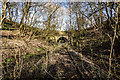
Keele Park Station (disused) and Bridge
The nearby Keele estate had its own railway station called Keele, Keele Park Race station was added later on the Newcastle to Market Drayton railway line to make the racecourse more accessible to racegoers. Keele Park station opened in 1896 and closed in March 1907, coinciding with the operation of the racecourse.
The Market Drayton branch railway opened in sections, with Stoke on Trent to Newcastle-under-Lyme being the first to open on the 6th September 1852. This was followed eleven years later by the Newcastle to Silverdale section in May of 1863. It wasn't until the 1st of February 1870 that the connection to Market Drayton was completed, giving Madeley an east-west route. Although initially the line was double track, it was converted to single track in 1934.
Passenger services were withdrawn on May 6th 1956 and the Silverdale to Stoke on Trent section closed on 2nd March 1964. Keele Station was closed in 1961. It was finally closed to goods trains on the 9th January 1967, although coal trains still ran from Silverdale colliery to Madeley Road and onto the former LNWR line. With the closure of Silverdale colliery in 1998, all traffic on this line ceased.
https://www.keele.ac.uk/thekeeleoralhistoryproject/railwaysatkeele/
https://en.wikipedia.org/wiki/Stoke_to_Market_Drayton_Line
Image: © Brian Deegan
Taken: 8 Feb 2020
0.17 miles
7
Keele Park Station 1896 -1907 (disused)
The nearby Keele estate had its own railway station called Keele, Keele Park Race station was added later on the Newcastle to Market Drayton railway line to make the racecourse more accessible to racegoers. Keele Park station opened in 1896 and closed in March 1907, coinciding with the operation of the racecourse.
The Market Drayton branch railway opened in sections, with Stoke on Trent to Newcastle-under-Lyme being the first to open on the 6th September 1852. This was followed eleven years later by the Newcastle to Silverdale section in May of 1863. It wasn't until the 1st of February 1870 that the connection to Market Drayton was completed, giving Madeley an east-west route. Although initially the line was double track, it was converted to single track in 1934.
Passenger services were withdrawn on May 6th 1956 and the Silverdale to Stoke on Trent section closed on 2nd March 1964. Keele Station was closed in 1961. It was finally closed to goods trains on the 9th January 1967, although coal trains still ran from Silverdale colliery to Madeley Road and onto the former LNWR line. With the closure of Silverdale colliery in 1998, all traffic on this line ceased.
https://www.keele.ac.uk/thekeeleoralhistoryproject/railwaysatkeele/
https://en.wikipedia.org/wiki/Stoke_to_Market_Drayton_Line
Image: © Brian Deegan
Taken: 8 Feb 2020
0.17 miles
8
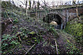
Landslip and Bridge, Keele Park Station
The nearby Keele estate had its own railway station called Keele, Keele Park Race station was added later on the Newcastle to Market Drayton railway line to make the racecourse more accessible to racegoers. Keele Park station opened in 1896 and closed in March 1907, coinciding with the operation of the racecourse.
The Market Drayton branch railway opened in sections, with Stoke on Trent to Newcastle-under-Lyme being the first to open on the 6th September 1852. This was followed eleven years later by the Newcastle to Silverdale section in May of 1863. It wasn't until the 1st of February 1870 that the connection to Market Drayton was completed, giving Madeley an east-west route. Although initially the line was double track, it was converted to single track in 1934.
Passenger services were withdrawn on May 6th 1956 and the Silverdale to Stoke on Trent section closed on 2nd March 1964. Keele Station was closed in 1961. It was finally closed to goods trains on the 9th January 1967, although coal trains still ran from Silverdale colliery to Madeley Road and onto the former LNWR line. With the closure of Silverdale colliery in 1998, all traffic on this line ceased.
https://www.keele.ac.uk/thekeeleoralhistoryproject/railwaysatkeele/
https://en.wikipedia.org/wiki/Stoke_to_Market_Drayton_Line
Image: © Brian Deegan
Taken: 8 Feb 2020
0.17 miles