IMAGES TAKEN NEAR TO
Stanier Street, NEWCASTLE, ST5 2SY
Introduction
This page details the photographs taken nearby to Stanier Street, ST5 2SY by members of the Geograph project.
The Geograph project started in 2005 with the aim of publishing, organising and preserving representative images for every square kilometre of Great Britain, Ireland and the Isle of Man.

There are currently over 7.5m images from over14,400 individuals and you can help contribute to the project by visiting https://www.geograph.org.uk
Image Map
Images are licensed for reuse under creativecommons.org/licenses/by-sa/2.0
Notes
- Clicking on the map will re-center to the selected point.
- The higher the marker number, the further away the image location is from the centre of the postcode.
Image Listing (326 Images Found)
Images are licensed for reuse under creativecommons.org/licenses/by-sa/2.0
Image
Details
Distance
1

Newcastle-Under-Lyme : Lidl
A Lidl on Lower Street.
Image: © Lewis Clarke
Taken: 22 Sep 2019
0.05 miles
2
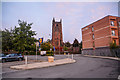
Newcastle-Under-Lyme : Car Park
Saint Giles Church overlooking the Lidl car park.
Image: © Lewis Clarke
Taken: 22 Sep 2019
0.05 miles
3
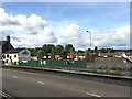
Newcastle-under-Lyme: building site on Lower Street
A comparison with Image shows that the extension behind Maxims has been demolished, and the rest of the site is under development, to become a 74 bed care home for the elderly with 28 apartments and ancillary facilities, while Maxims itself is to be refurbished for offices, a hair salon, café, bar and "heritage rooms".
Six weeks later this was the view http://www.geograph.org.uk/photo/5128612
Image: © Jonathan Hutchins
Taken: 13 Aug 2016
0.05 miles
4
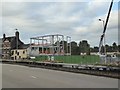
Newcastle-under-Lyme: building site on Lower Street
Pochin Construction are creating a 74 bed care home for the elderly with 28 apartments and ancillary facilities, while Maxims itself is to be refurbished for offices, a hair salon, café, bar and "heritage rooms".
For a view six weeks previously see http://www.geograph.org.uk/photo/5091391
For a view just over four months later see http://www.geograph.org.uk/photo/5272278
Image: © Jonathan Hutchins
Taken: 22 Sep 2016
0.05 miles
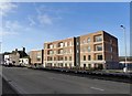
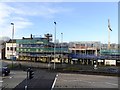
5
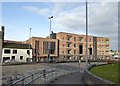
Belong Newcastle-under-Lyme
Belong Newcastle comprises a 74 bed care home for the elderly with 28 apartments and ancillary facilities, while the adjacent former nightclub itself is to be refurbished for offices, a hair salon, café, bar and "heritage rooms".
Website: https://www.belong.org.uk/locations/newcastle-under-lyme
The progress of construction:
Before Belong (April 2015) http://www.geograph.org.uk/photo/4432279
August 2016 http://www.geograph.org.uk/photo/5091391
September 2016 http://www.geograph.org.uk/photo/5128612
February 2017 http://www.geograph.org.uk/photo/5272278
Image: © Jonathan Hutchins
Taken: 21 Feb 2018
0.05 miles
6
Belong Newcastle-under-Lyme
Belong Newcastle comprises a 74 bed care home for the elderly with 28 apartments and ancillary facilities, while the adjacent former nightclub itself is to be refurbished for offices, a hair salon, café, bar and "heritage rooms".
Website: https://www.belong.org.uk/locations/newcastle-under-lyme
The progress of construction:
Before Belong (April 2015) http://www.geograph.org.uk/photo/4432279
August 2016 http://www.geograph.org.uk/photo/5091391
September 2016 http://www.geograph.org.uk/photo/5128612
February 2017 http://www.geograph.org.uk/photo/5272278
Image: © Jonathan Hutchins
Taken: 21 Feb 2018
0.05 miles
7
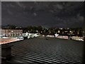
Newcastle-Under-Lyme : Town Scenery
From room 208 of the Travelodge .
Image: © Lewis Clarke
Taken: 22 Sep 2019
0.05 miles
8
Newcastle Under Lyme Castle Remains
Part of the castle of which very little remains.
The monument includes the earthwork, structural and buried remains of a motte and bailey castle, lying within two separate areas of protection. The extant structural remains of the castle are a Listed Building Grade II. The castle was built on low-lying ground and from this location there were extensive views of the surrounding land. The market centre of Newcastle-under-Lyme, probably established by the late 12th century, occupies the adjacent higher ground to the east.
The castle was probably founded in the early 12th century. In 1149 King Stephen granted the castle and the accompanying lands to Ranulf de Gernon, Earl of Chester. After Ranulf's death in 1153 the castle appears to have remained in royal control for many years and was staffed by officials appointed by the Crown. Numerous documentary references indicate that in the late 12th and early 13th centuries a considerable amount of work was being undertaken to strengthen the castle's defences, and to construct and repair the internal buildings. A major element of the castle's defence, mentioned at this time, was the large pool that surrounded the castle, which was created by damming the Lyme Brook and the adjacent streams. A bridge, connecting the castle to the land to the north east, was repaired in 1191 and two years later stone embattlements were added. Other buildings mentioned include the stone tower which stood on top of the motte, a chapel, private apartments, kitchens and a gaol. There are also references to timber palisades and to bretasches (or timber platforms) for the defence of the castle walls.
https://historicengland.org.uk/listing/the-list/list-entry/1020853
Image: © Brian Deegan
Taken: 23 May 2020
0.06 miles
9
Newcastle-under-Lyme: building development on Lower Street
Building work has moved on apace since the picture in September 2016 http://www.geograph.org.uk/photo/5128612 .
Pochin Construction are creating a 74 bed care home for the elderly with 28 apartments and ancillary facilities, while Maxims itself is to be refurbished for offices, a hair salon, café, bar and "heritage rooms".
Image: © Jonathan Hutchins
Taken: 4 Feb 2017
0.06 miles
10
Newcastle-under-Lyme: building development on Lower Street
Building work has moved on apace since the picture in September 2016 http://www.geograph.org.uk/photo/5128612 .
Pochin Construction are creating a 74 bed care home for the elderly with 28 apartments and ancillary facilities, while Maxims itself is to be refurbished for offices, a hair salon, café, bar and "heritage rooms".
The finished building a year later: https://www.geograph.org.uk/photo/5688214 and https://www.geograph.org.uk/photo/5688227
Image: © Jonathan Hutchins
Taken: 4 Feb 2017
0.06 miles