IMAGES TAKEN NEAR TO
Lancaster Crescent, STOKE-ON-TRENT, ST4 6BX
Introduction
This page details the photographs taken nearby to Lancaster Crescent, ST4 6BX by members of the Geograph project.
The Geograph project started in 2005 with the aim of publishing, organising and preserving representative images for every square kilometre of Great Britain, Ireland and the Isle of Man.

There are currently over 7.5m images from over14,400 individuals and you can help contribute to the project by visiting https://www.geograph.org.uk
Image Map
Images are licensed for reuse under creativecommons.org/licenses/by-sa/2.0
Notes
- Clicking on the map will re-center to the selected point.
- The higher the marker number, the further away the image location is from the centre of the postcode.
Image Listing (75 Images Found)
Images are licensed for reuse under creativecommons.org/licenses/by-sa/2.0
Image
Details
Distance
1
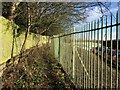
Footpath boundary behind Royal Stoke University Hospital
A little further north along Image] the path has widened out. Behind the railings on the right is the back of the hospital's multistorey car park.
Image: © Jonathan Hutchins
Taken: 30 Jan 2015
0.02 miles
2
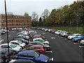
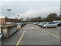
Royal Stoke University Hospital: car park
This ground-level staff car park can be accessed only from the multistorey car park, from the roof of which this picture was taken. In the background is the Springfield Building which houses the Trust headquarters, and which can be seen from the other side in http://www.geograph.org.uk/photo/4313053 .
Image: © Jonathan Hutchins
Taken: 4 Nov 2015
0.03 miles
4
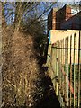
Footpath boundary behind Royal Stoke University Hospital
This barely used footpath, FP Newcastle 156, is the boundary between the Borough of Newcastle-under-Lyme and the unitary authority of Stoke-on-Trent. On the right of the railings is the Royal Stoke University Hospital specifically the back of the Springfield Building http://www.geograph.org.uk/photo/4313053.
The top (north) end is http://www.geograph.org.uk/photo/4327915.
Image: © Jonathan Hutchins
Taken: 30 Jan 2015
0.05 miles
5
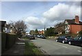
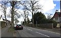
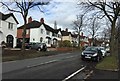
Newcastle-under-Lyme: Lancaster Road
Image: © Jonathan Hutchins
Taken: 27 Feb 2015
0.05 miles
6
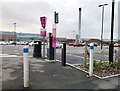
Car park furniture at the Royal Stoke University Hospital
Image: © Jonathan Hutchins
Taken: 1 Apr 2017
0.06 miles
7
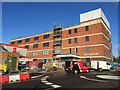
Royal Stoke University Hospital: Springfield Building
The headquarters of the University Hospitals of North Midlands NHS Trust relocated here at the beginning of January 2015 from the old Parish Buildings.
Image: © Jonathan Hutchins
Taken: 16 Jan 2015
0.06 miles
8
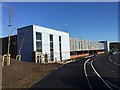
Royal Stoke University Hospital: multistorey car park
This can be used by both staff and patients & visitors.
Image: © Jonathan Hutchins
Taken: 16 Jan 2015
0.07 miles
9
Royal Stoke University Hospital: multistorey car park
The top deck, level 3a. Occupancy of the car park is varied between staff and patients & visitors depending on need and availability of on-site parking elsewhere. Currently the multistorey car park is assigned to hospital staff except for level 1, which is for patients & visitors.
To the left can be seen the Springfield Building http://www.geograph.org.uk/photo/4313053.
Image: © Jonathan Hutchins
Taken: 26 Jan 2015
0.07 miles
10
Newcastle-under-Lyme: The Avenue
Image: © Jonathan Hutchins
Taken: 25 Feb 2015
0.07 miles