IMAGES TAKEN NEAR TO
Freckleton Place, STOKE-ON-TRENT, ST3 7SG
Introduction
This page details the photographs taken nearby to Freckleton Place, ST3 7SG by members of the Geograph project.
The Geograph project started in 2005 with the aim of publishing, organising and preserving representative images for every square kilometre of Great Britain, Ireland and the Isle of Man.

There are currently over 7.5m images from over14,400 individuals and you can help contribute to the project by visiting https://www.geograph.org.uk
Image Map (Loading...)


Getting Data...Please wait
Leaflet Map data © OpenStreetMap
Images are licensed for reuse under creativecommons.org/licenses/by-sa/2.0
Notes
- Clicking on the map will re-center to the selected point.
- The higher the marker number, the further away the image location is from the centre of the postcode.
Image Listing (6 Images Found)
Images are licensed for reuse under creativecommons.org/licenses/by-sa/2.0
Image
Details
Distance
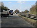
1
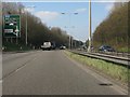
A50 at Blythe Bridge
The western junctions on the Blythe Bridge bypass are very closely spaced. A keen eye will spot not only the entry slip road from the B5029, but also, in the far distance the rising exit slip road for the next junction with the A521.
Image: © Peter Whatley
Taken: 24 Mar 2011
0.18 miles
2
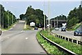
A50 Approaching Stoke-on-Trent at Blythe Bridge Bypass Junction (A521)
Image: © David Dixon
Taken: 8 Aug 2014
0.19 miles
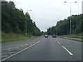
4
Westbound off slip road from A50 to A521
Image: © David Smith
Taken: 23 Jul 2013
0.20 miles
5
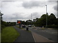
North end of Lysander Road, Meir Park
Looking towards the roundabout that provides access to the A50 and to Blythe Bridge via Uttoxeter Road.
Image: © Richard Vince
Taken: 29 Jun 2013
0.23 miles
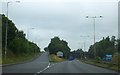
6
A50 approaching Uttoxeter Road junction (A521)
A classic UK roundabout junction with the added bonus of a Tesco superstore selling cheap fuel adjoining it.
Image: © Peter Whatley
Taken: 24 Mar 2011
0.25 miles