IMAGES TAKEN NEAR TO
Windmill Hill, STOKE-ON-TRENT, ST3 7PL
Introduction
This page details the photographs taken nearby to Windmill Hill, ST3 7PL by members of the Geograph project.
The Geograph project started in 2005 with the aim of publishing, organising and preserving representative images for every square kilometre of Great Britain, Ireland and the Isle of Man.

There are currently over 7.5m images from over14,400 individuals and you can help contribute to the project by visiting https://www.geograph.org.uk
Image Map
Images are licensed for reuse under creativecommons.org/licenses/by-sa/2.0
Notes
- Clicking on the map will re-center to the selected point.
- The higher the marker number, the further away the image location is from the centre of the postcode.
Image Listing (15 Images Found)
Images are licensed for reuse under creativecommons.org/licenses/by-sa/2.0
Image
Details
Distance
1
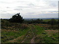
Rough Close
Just visible (if you look VERY hard in a direct continuation from the path!) is The Wrekin, about 30 miles away
Image: © Linda Mellor
Taken: 26 Sep 2005
0.09 miles
3
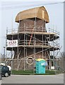
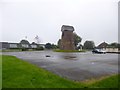
Meir Heath Windmill restoration
The wood has weathered a little in the last month since Image
If the Meir Heath Windmill Preservation Group can raise £20000 they plan to waterproof render the walls and repair the guttering. Plans are to open this as an information centre.
The Grade 2 listed mill was built in the 18th century. It remained in use until the late 1890s and was later a water tower. The sails were removed during service as a wartime observation post by the Home Guard.
Image: © John M
Taken: 10 Apr 2010
0.19 miles
5
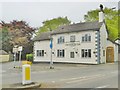
Rough Close, Swynnerton Arms
Roadside public house at the corner of Lightwood Road and Windmill Hill. Entrance from rear; central counter, with drinking & eating areas left, and dining right. Background music, games machine, patio. Cask ales on offer at my visit: Bass, Greene King Abbot, Sharp's Doom Bar.
Image: © Mike Faherty
Taken: 11 May 2018
0.21 miles
6
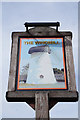
The Windmill at Meir Heath
http://www.geograph.org.uk/photo/4891982 http://www.geograph.org.uk/photo/4891983
Image: © Ian S
Taken: 29 Mar 2016
0.21 miles
7
The Windmill at Meir Heath
http://www.geograph.org.uk/photo/4891983 http://www.geograph.org.uk/photo/4891988
Image: © Ian S
Taken: 29 Mar 2016
0.22 miles
8
The Windmill at Meir Heath
http://www.geograph.org.uk/photo/4891988 http://www.geograph.org.uk/photo/4891982
Image: © Ian S
Taken: 29 Mar 2016
0.22 miles
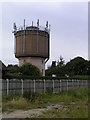
9
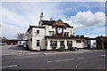
Meir Heath, windmill
In the car park of The Windmill public house; the mill is C18, and has also served as water tank, Home Guard post and communications tower; now awaiting restoration. http://www.meirheathwindmill.com/Meir-Heath-Windmill
Image: © Mike Faherty
Taken: 8 Oct 2012
0.23 miles
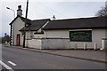
10
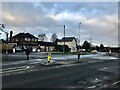
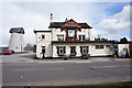
Post Office at Meir Heath
Pictured from a usually busy intersection on Windmill Hill. The post office is in the centre of picture and the still-surviving windmill itself is out of picture to the right.
Image: © Jonathan Clitheroe
Taken: 21 Jan 2021
0.23 miles