IMAGES TAKEN NEAR TO
Broadway, STOKE-ON-TRENT, ST3 5LG
Introduction
This page details the photographs taken nearby to Broadway, ST3 5LG by members of the Geograph project.
The Geograph project started in 2005 with the aim of publishing, organising and preserving representative images for every square kilometre of Great Britain, Ireland and the Isle of Man.

There are currently over 7.5m images from over14,400 individuals and you can help contribute to the project by visiting https://www.geograph.org.uk
Image Map
Images are licensed for reuse under creativecommons.org/licenses/by-sa/2.0
Notes
- Clicking on the map will re-center to the selected point.
- The higher the marker number, the further away the image location is from the centre of the postcode.
Image Listing (13 Images Found)
Images are licensed for reuse under creativecommons.org/licenses/by-sa/2.0
Image
Details
Distance
1
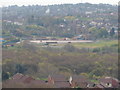
Remains of Longton High School
Built about 1964 the 3rd incarnation of Longton High School served 3 generations of students before being demolished by explosives in December 2011. Falling school rolls and structural problems of the seven-storey main block spelled the end for this former landmark building. Also gone are the gym, main hall, dining hall and swimming pool plus the former caretaker's house. Some of the newer buildings on the site plus the extensive playing fields have been retained for future use.
Image: © Chris Beaver
Taken: 6 May 2013
0.14 miles
2
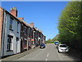
Meir View
Meir View, a street near the town centre.
Image: © David Weston
Taken: 3 May 2017
0.18 miles
4
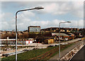
Longton High School during A50 construction
Taken during the summer of 1997 during the A50 upgrade to dual-carriageway, this photo shows the now-demolished main block of Longton High School. It was levelled in December of 2011 using explosives. The six-storey building first opened in 1964 but suffered from structural problems probably due to nearby coal mining. This is the reason why Stoke-on-Trent has very few high-rise structures when compared with other cities of similar size. Some of the newer school buildings on the site have been retained for future use.
Image: © Chris Beaver
Taken: Unknown
0.19 miles
5
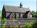
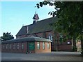
Holy Trinity Church, Meir
The church was built in the 1890s. Viewed from across the A50, several yards below; a short distance away, the A50 enters the tunnel under the roundabout at Meir.
Image: © David Weston
Taken: 3 May 2017
0.21 miles
7
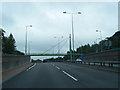
Footbridge over A50 west of Meir Tunnel
The wall on the left is the side wall of the slope up from the tunnel. The bridge is cable-stayed
Image: © David Smith
Taken: 23 Jul 2013
0.23 miles
9
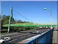
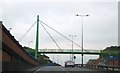
Footbridge over the A50 at Meir
A cable-stayed footbridge over the A50.
Image: © David Weston
Taken: 3 May 2017
0.23 miles
10
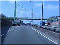
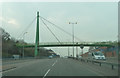
A50 - cable-stayed footbridge west of Meir Tunnel
A unique structure on the widened A50 route through the Potteries towns.
Image: © Peter Whatley
Taken: 24 Mar 2011
0.24 miles