IMAGES TAKEN NEAR TO
Romney Grove, STOKE-ON-TRENT, ST3 4TU
Introduction
This page details the photographs taken nearby to Romney Grove, ST3 4TU by members of the Geograph project.
The Geograph project started in 2005 with the aim of publishing, organising and preserving representative images for every square kilometre of Great Britain, Ireland and the Isle of Man.

There are currently over 7.5m images from over14,400 individuals and you can help contribute to the project by visiting https://www.geograph.org.uk
Image Map (Loading...)


Getting Data...Please wait
Leaflet Map data © OpenStreetMap
Images are licensed for reuse under creativecommons.org/licenses/by-sa/2.0
Notes
- Clicking on the map will re-center to the selected point.
- The higher the marker number, the further away the image location is from the centre of the postcode.
Image Listing (4 Images Found)
Images are licensed for reuse under creativecommons.org/licenses/by-sa/2.0
Image
Details
Distance
1
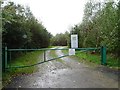
Entrance and track
Gate and entrance to Infinis, a UK energy company.
Image: © Philip Halling
Taken: 21 Sep 2018
0.18 miles
2
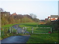
Walkway, Cocknage Lane
Just off Cocknage Lane, Dresden, Stoke on Trent this walkway used to be part of a railway line into Florence Colliery, one of the most productive in the region. Alas no more, now a housing estate.
Image: © Phil Eptlett
Taken: 27 Nov 2006
0.18 miles
3
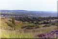
Towards Cocknage Wood and Florence Colliery
Taken from Parkhall Hills Country Park in the mid 1980's before the demolition of the Florence Pit concrete headgear building. Also visible far left is the 6-storey main block of Longton High School which was demolished in December 2011.
Image: © Chris Beaver
Taken: Unknown
0.18 miles
4
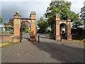
Park entrance
Gate piers at the entrance to Queen's Park near Dresden.
Image: © Philip Halling
Taken: 21 Sep 2018
0.24 miles