IMAGES TAKEN NEAR TO
Probyn Court, STOKE-ON-TRENT, ST3 4SR
Introduction
This page details the photographs taken nearby to Probyn Court, ST3 4SR by members of the Geograph project.
The Geograph project started in 2005 with the aim of publishing, organising and preserving representative images for every square kilometre of Great Britain, Ireland and the Isle of Man.

There are currently over 7.5m images from over14,400 individuals and you can help contribute to the project by visiting https://www.geograph.org.uk
Image Map
Images are licensed for reuse under creativecommons.org/licenses/by-sa/2.0
Notes
- Clicking on the map will re-center to the selected point.
- The higher the marker number, the further away the image location is from the centre of the postcode.
Image Listing (12 Images Found)
Images are licensed for reuse under creativecommons.org/licenses/by-sa/2.0
Image
Details
Distance

2
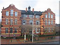
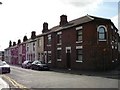
Sutherland Institute, Longton
Completed in 1898 on land donated by the Duke of Sutherland who lived at nearby Trentham Hall. The building is now one of Stoke on Trent's libraries and also houses the Hothouse Project to help fledgling businesses
Image: © Phil Eptlett
Taken: 14 Feb 2006
0.15 miles
5
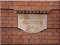
Date Plaque on Sutherland Institute
Wood & Hutchings, Architects, 1898
Date plaque on the side of the Sutherland Institute, Longton.
See the Sutherland Institute: http://www.geograph.org.uk/photo/122101
Image: © Steven Birks
Taken: 19 Sep 2006
0.19 miles
7
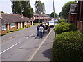
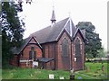
Horse-drawn carriage, Dresden
Off for the wedding photographs!
Looking down Cobden Street, from junction with Carlisle Street. The building on the right is Longton Elim Church, Dresden, Stoke-on-Trent. ST3 4EN
Image: © Carl Farnell
Taken: 17 Jun 2006
0.21 miles
8
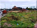
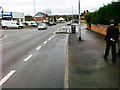
Cliveden Place, Longton
Cliveden Place is a street close to the A50 road.
Just by the top of Cliveden Place is the Sutherland Institute: http://www.geograph.org.uk/photo/122101
Image: © Steven Birks
Taken: 19 Sep 2006
0.21 miles
9
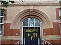
Entrance to Sutherland Institute, Longton
Impressive entrance to the Sutherland Institute and Free Library.
See photo of the main building:- http://www.geograph.org.uk/photo/122101
Image: © Steven Birks
Taken: 19 Sep 2006
0.21 miles
10
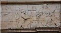
Panel above entrance to Sutherland Institute, Longton
In the centre of the frieze an enthroned female figure sits with a cherubic figure seated at her feet. A group of workers kneel before her as they present her with the finished products of their labours.
Over the windows, a bass relief terracotta frieze illustrates scenes of the industries of Pottery, Mining, and Metal Processing.
The Institute was opened by the Duke of Sutherland on 28 October 1899, but at that time the space now occupied by the frieze remained empty. It was only in 1908 that funds became available for the addition of this piece.
See photo of the main building:- http://www.geograph.org.uk/photo/122101
Image: © Steven Birks
Taken: 19 Sep 2006
0.21 miles