IMAGES TAKEN NEAR TO
Lowfield Lane, STAFFORD, ST20 0ET
Introduction
This page details the photographs taken nearby to Lowfield Lane, ST20 0ET by members of the Geograph project.
The Geograph project started in 2005 with the aim of publishing, organising and preserving representative images for every square kilometre of Great Britain, Ireland and the Isle of Man.

There are currently over 7.5m images from over14,400 individuals and you can help contribute to the project by visiting https://www.geograph.org.uk
Image Map
Images are licensed for reuse under creativecommons.org/licenses/by-sa/2.0
Notes
- Clicking on the map will re-center to the selected point.
- The higher the marker number, the further away the image location is from the centre of the postcode.
Image Listing (33 Images Found)
Images are licensed for reuse under creativecommons.org/licenses/by-sa/2.0
Image
Details
Distance
1
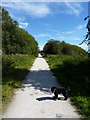
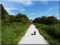
The Way for the Millennium
The converted LNWR Stafford to Newport railway, here looking towards the Stafford direction. It's a pleasant walk or bike ride.
Image: © Richard Law
Taken: 8 Sep 2012
0.10 miles
2
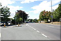
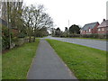
Road Junction on A518 Gnosall
The road to the left goes down to the Primary school,Youth centre and farther on to Springfield Farm
Image: © Mick Malpass
Taken: 21 Aug 2011
0.11 miles
3
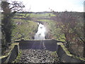
Drainage ditch viewed from the Way for the Millennium near Gnosall
I love a drainage ditch. Where is my bog snorkelling gear?
Image: © Jeremy Bolwell
Taken: 20 Jan 2022
0.12 miles
4
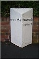
Old Milepost by the A518, Stafford Road, Gnosall
Cast iron post by the A518, in parish of GNOSALL (STAFFORD District), Gnosall village, in path in front of low brick wall, on South side of road. Lathe iron casting, erected by the County Council in the 19th/20th century.
Inscription reads:-
: NEWPORT 5½ : : GNOSALL : : HAUGHTON 2½ / STAFFORD 7 :
Maker:-
: Chas. Lathe, Tipton. :
Staffordshire HER listed.
HER Number: 51324 https://www.heritagegateway.org.uk/Gateway/Results_Single.aspx?uid=MST12547&resourceID=1010
Milestone Society National ID: ST_STNP07.
Image: © J Higgins
Taken: 1 Jan 2000
0.13 miles
5
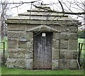
Gnosall Village Lock-up
"The village is also home to an old "Lock up".(14th Century) It is now situated between the Norman Church and the modern cemetery, and is visible from the A518, bound for Stafford. The purpose was as a mini prison, and it fits the bill with sinister efficiency visually, with its strong riveted and bolted door, no windows or other openings and thick sandstone walls. It was originally located nearer to where the mini round-about is now situated, but was carefully moved, brick by brick.(in 1931)" Quoted from Wikipedia.
Image: © stephen betteridge
Taken: 24 Mar 2007
0.15 miles
6
The Stafford Road on the SE side of Gnosall
A mixture of new and older properties on the main road through the village.
Image: © Richard Law
Taken: 9 Apr 2016
0.15 miles
7
Under Lowfield Lane
The Way for the Millennium takes a bit of a kink as it passes under the bridge carrying Lowfield Lane to Springfield Farm.
Image: © Richard Law
Taken: 9 Apr 2016
0.16 miles
8
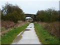
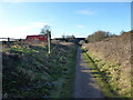
Heading for the Lowfield Lane bridge
Lowfield Lane crosses the old LNWR railway on the bridge 100 yards ahead, giving access to Springfield Farm.
Image: © Richard Law
Taken: 8 Sep 2012
0.17 miles
9
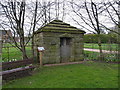
The Gnosall Lock-up
Dating from 1820, and originally located at the junction of High Street, Brookhouse Road and Stafford Street (ie roughly at the sharp bend on the main road in Image), this windowless building was erected at the request of the town's Select Vestry (an early form of town council) who were concerned that no facilities existed locally for the proper confinement of criminals.
In the end, it had little use, and fell into disrepair in the mid 20th century, then was all but demolished when a vehicle struck it in 1969 or 1970. At the insistence of the local Women's Institute, it avoided being relocated to Shugborough Hall, and was moved to a small parcel of land donated for the purpose of its preservation in 1971.
Image: © Richard Law
Taken: 9 Apr 2016
0.17 miles
10
Walking the Way for the Millennium near Gnosall
The Way has its own Wikipedia page, https://en.wikipedia.org/wiki/Way_for_the_Millennium here.
Image: © Jeremy Bolwell
Taken: 20 Jan 2022
0.17 miles