
IMAGES TAKEN NEAR TO
Wordsworth Avenue, STAFFORD, ST17 9UE
Introduction
This page details the photographs taken nearby to Wordsworth Avenue, ST17 9UE by members of the Geograph project.
The Geograph project started in 2005 with the aim of publishing, organising and preserving representative images for every square kilometre of Great Britain, Ireland and the Isle of Man.

There are currently over 7.5m images from over14,400 individuals and you can help contribute to the project by visiting https://www.geograph.org.uk
Image Map
Images are licensed for reuse under creativecommons.org/licenses/by-sa/2.0
Notes
- Clicking on the map will re-center to the selected point.
- The higher the marker number, the further away the image location is from the centre of the postcode.
Image Listing (16 Images Found)
Images are licensed for reuse under creativecommons.org/licenses/by-sa/2.0
Image
Details
Distance
1
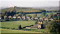
View over fields from the roof of Brooke Court
This is the view over fields from the roof of Brooke Court (which was adjacent to Image) as it existed in the autumn of 1969. The row of houses in the middle distance are on Castle Bank (A518) which, to the right, becomes Newport Road.
A short distance to the left (south-west) the A518 passes under the M6 motorway.
In the distance, on the hill, are the ruins of Stafford Castle.
Since this photograph was taken all the fields in the foreground have been built over with housing and the farm house demolished.
To see almost the same view, but early on a foggy morning, click here: http://www.geograph.org.uk/photo/2244917 .
See this photograph by Simon Huguet http://www.geograph.org.uk/photo/1136212 , which shows the view (2009) back toward the viewpoint of this photograph and in which can be seen the Milton Court.
Milton Court and Brooke Court were on the same site, although Brooke Court has since been demolished.
- - -
Note: The Date Taken is the processing date printed on the slide and therefore the photograph could have been taken several weeks earlier.
Image: © Alan Walker
Taken: Unknown
0.16 miles
3
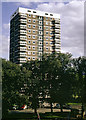
Binyon Court
This photograph was taken from Brooke Court, a very similar structure which at the time this photograph was taken was accommodation for students at the Image
Milton Court has been significantly modified (for example, the balconies have been removed) and Brooke Court has been pulled down to be replaced by a small housing development.
- - -
Click here http://www.geograph.org.uk/photo/2243531 for a north-westerly view from the roof of Brooke Court.
- - -
Note: The Date Taken is the processing date printed on the slide and therefore the photograph could have been taken several weeks earlier.
Image: © Alan Walker
Taken: Unknown
0.17 miles
4
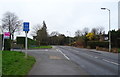
End of cycle route beside Newport Road, Stafford
Image: © JThomas
Taken: 14 Mar 2020
0.19 miles
5
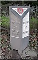
Old Boundary Marker by the A518, Newport Road, Stafford parish
Parish Boundary Marker by the A518, in parish of Stafford (Stafford District), Newport Road, West of parish church entrance.
Surveyed
Milestone Society National ID: ST_SFCC01pb
Image: © Mike Faherty
Taken: 15 Jan 2011
0.20 miles
7
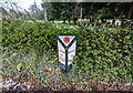
Parish Boundary Marker, Stafford
1917 Cast Iron Parish Marker Post
Image: © Brian Deegan
Taken: 10 Apr 2021
0.22 miles
8
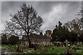
St. Lawrence Church, Stafford Castle
Norman style, but was rebuilt in 1844, in the same style.
Image: © Brian Deegan
Taken: 10 Apr 2021
0.23 miles
9
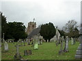
Stafford, Castle Church
Parish church of St. Lawrence, on Newport Road. http://www.castlechurch.org.uk/
Image: © Mike Faherty
Taken: 15 Jan 2011
0.23 miles
10
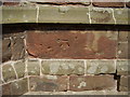
Ordnance Survey bolt on Castle Church
This bench mark was established some time around 1858 during the First primary levelling of England & Wales, and was levelled with a height of 331.3080 feet [100.9827 metres] above mean sea level (Liverpool datum). It was included on the Llandysilio to Stafford levelling line. The surveyor's description was No. 108. Bolt in South-west angle of Castlechurch Church tower ; 2.90 ft. above surface (p588).
Image: © Shantavira
Taken: 27 Jul 2013
0.23 miles